Ar-Rutba District
قضاء الرطبة | |
|---|---|
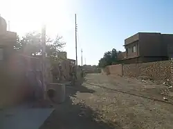 Street scene in Ar-Rutba town (2004) Ar-Rutba is the largest, southernmost and westernmost of the districts in Al Anbar Governorate | |
 | |
| Coordinates: 33°2′17″N 40°17′4″E / 33.03806°N 40.28444°E | |
| Country | |
| Governorates | Al Anbar Governorate |
| Seat | Ar-Rutba |
| Area | |
| • Total | 93,445 km2 (36,079 sq mi) |
| Population 2003-01 (est.) | |
| • Total | 24,813 |
| • Density | 0.27/km2 (0.7/sq mi) |
| Time zone | UTC+3 (AST) |
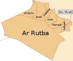
Ar-Rutba District (Arabic: قضاء الرطبة) is the largest district by area in Al Anbar Governorate, Iraq, covering 93,445 km2, and the least populated in relative and absolute terms, with a population of 24,813 (estimate January 2003), or 0.27 per km2.[1] It is also the southernmost district of Al Anbar Governorate, the westernmost of the whole country, and the only district nationwide bordering Jordan. It is centred on the town of Ar-Rutba.
Cities
References
This article is issued from Wikipedia. The text is licensed under Creative Commons - Attribution - Sharealike. Additional terms may apply for the media files.