40°47′01″N 43°57′15″E / 40.78361°N 43.95417°E
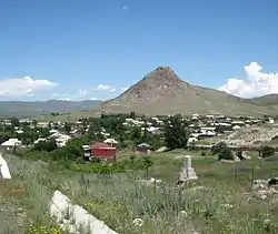
Karnut
Կառնուտ | |
|---|---|
 | |
 Karnut  Karnut | |
| Coordinates: 40°47′01″N 43°57′15″E / 40.78361°N 43.95417°E | |
| Country | Armenia |
| Province | Shirak |
| Municipality | Akhuryan |
| Population (2001) | |
| • Total | 992 |
| Time zone | UTC+4 |
| • Summer (DST) | UTC+5 |
Karnut (Armenian: Կառնուտ) is a village in the Akhuryan Municipality of the Shirak Province of Armenia.
Demographics
The population of the village since 1831 is as follows:[1]
| Year | Population |
|---|---|
| 1831 | 151 |
| 1897 | 965 |
| 1926 | 1,149 |
| 1939 | 1,136 |
| 1959 | 783 |
| 1970 | 719 |
| 1979 | 667 |
| 2001 | 992 |
| 2004 | 965 |
References
- ↑ Հայաստանի Հանրապետության բնակավայրերի բառարան [Republic of Armenia settlements dictionary] (PDF) (in Armenian). Yerevan: Cadastre Committee of the Republic of Armenia. 2008. Archived from the original (PDF) on 11 March 2018.
- Karnut at GEOnet Names Server
- Report of the results of the 2001 Armenian Census, Statistical Committee of Armenia
Capital: Gyumri | ||
| Urban settlements |  | |
| Akhuryan Municipality | ||
| Amasia Municipality | ||
| Ani Municipality | ||
| Artik Municipality | ||
| Ashotsk Municipality | ||
This article is issued from Wikipedia. The text is licensed under Creative Commons - Attribution - Sharealike. Additional terms may apply for the media files.