| Guéra Prefecture Préfecture du Guéra | |||||||||||
|---|---|---|---|---|---|---|---|---|---|---|---|
| Prefecture of Chad | |||||||||||
| 1960–1999 | |||||||||||
 | |||||||||||
 | |||||||||||
| Capital | Mongo | ||||||||||
| Area | |||||||||||
| • Coordinates | 12°10′N 18°41′E / 12.167°N 18.683°E | ||||||||||
• 1960 | 60,000 km2 (23,000 sq mi) | ||||||||||
• 1993 | 58,950 km2 (22,760 sq mi) | ||||||||||
| Population | |||||||||||
• 1960 | 156002 | ||||||||||
• 1993 | 306253 | ||||||||||
| • Type | Prefecture | ||||||||||
| Historical era | Cold War | ||||||||||
• Established[1] | 13 February 1960 | ||||||||||
• Disestablished[1] | 1 September 1999 | ||||||||||
| Political subdivisions | Sub-prefectures (1993)[2]
| ||||||||||
| |||||||||||
| Area and population source:[1] | |||||||||||
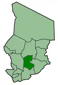
Guéra was one of the 14 prefectures of Chad. Its capital was Mongo. Located in the south of the country, Guéra covered an area of 58,950 square kilometers and had a population of 306,253 in 1993, of which 263,843 were sedentary (rural: 219,884; urban: 43,959) and 42,810 were nomadic. The predominant ethno-linguistic groups were the Hadjerai (66.18%) and the Arabs (21.11%).
See also
References
- 1 2 3 "Administrative Divisions of Countries: Regions of Chad". www.statoids.com.
- ↑ "Administrative Divisions of Countries: Departments of Chad". www.statoids.com.
| |||
|
Batha · Biltine · Borkou-Ennedi-Tibesti · Chari-Baguirmi · Guéra · Kanem · Lac · Logone Occidental · Logone Oriental · Mayo-Kébbi · Moyen-Chari · Ouaddaï · Salamat · Tandjilé · | |||
|
See also : Regions of Chad - Departments of Chad |
This article is issued from Wikipedia. The text is licensed under Creative Commons - Attribution - Sharealike. Additional terms may apply for the media files.