| Jasper SkyTram | |
|---|---|
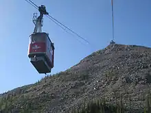 The Jasper SkyTram from below in 2009 | |
 | |
| Overview | |
| Status | Operational |
| Character | Recreational |
| Location | Whistlers Road, Jasper, Alberta |
| Country | Canada |
| Coordinates | 52°51′05″N 118°07′26″W / 52.85147°N 118.12375°W |
| Open | 1964 |
| Website | www |
| Operation | |
| Trip duration | 7 min |
| Technical features | |
| Aerial lift type | Aerial tramway |
| Manufactured by | P.H.B. Company |
| No. of support towers | 1 |
| No. of cables | 2 |
| Cable diameter | Track rope cable: 46 mm. Hauling rope: 27 mm. |
| Operating speed | 6 m/s |
The Jasper SkyTram is an aerial tramway on the mountain called The Whistlers near Jasper, Alberta, Canada. It is the highest and longest guided aerial tramway in Canada.[1] It goes to a height of 2,263 metres (7,425 ft) above sea level with a travel time of 7.5 minutes. From the upper tramway station, the hike to the Whistlers Summit is 1.4 kilometres, and is a 200-metre (660 ft) elevation gain to 2,463 metres (8,081 ft). It is 7 kilometres (4.3 mi) south of Jasper, off the Icefields Parkway on Whistlers Road. It is a seasonal operation, running from late March to the end of October. It has been in operation since it was built in 1964.[2]
References
- ↑ "Ride the Tram". Jasper Skytram. Retrieved May 13, 2014.
- ↑ "Our Jasper Stories: The history of Jasper SkyTram". The Fitzhugh. 7 September 2020. Retrieved 17 September 2020.
External links
Wikimedia Commons has media related to Jasper Tramway.
This article is issued from Wikipedia. The text is licensed under Creative Commons - Attribution - Sharealike. Additional terms may apply for the media files.