| Seefelder Aach Salemer Aach, Linzer Aach | |
|---|---|
 | |
| Location | |
| Country | Germany |
| State | Baden-Württemberg |
| Region | Tübingen |
| Physical characteristics | |
| Source | |
| • location | Between Alberweiler and Herdwangen in Herdwangen-Schönach |
| • elevation | 670 m (2,200 ft) |
| Mouth | |
• location | Next to Seefelden in Uhldingen-Mühlhofen into Lake Constance |
• coordinates | 47°43′59″N 9°13′35″E / 47.7331°N 9.2264°E |
• elevation | 395 m (1,296 ft) |
| Length | 54.7 km (34.0 mi) [1] |
| Basin size | 279 km2 (108 sq mi) [1] |
| Basin features | |
| Progression | Rhine→ North Sea |
| Tributaries | |
| • left | Furtbach, Erlengraben, Aubach, Deggenhauser Aach, Gießbach |
| • right | Herdenbach, Wäschbach, Torpenbach, Nellenflurb |
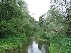
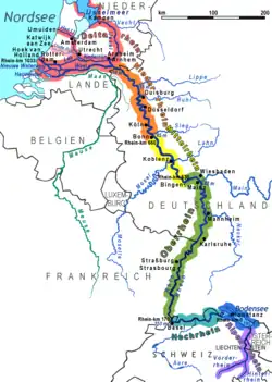
The Seefelder Aach is a river in the districts of Sigmaringen and Bodenseekreis, Tübingen region, southern Baden-Württemberg, Germany. It is approximately 55 kilometres long and flows into Lake Constance. It has a catchment area of 279 km² and is part of the Rhine river system. It starts as Salemer Aach and becomes the Seefelder Aach after the conjunction with the Deggenhauser Aach, further down from Salem.[1] The upper part – near Aach-Linz – it is also colloquially called Linzer Aach or Hintere Aach.[2][3]
References
- 1 2 3 Map services of the Baden-Württemberg State Office for the Environment, Survey and Conservation (Landesanstalt für Umwelt, Messungen und Naturschutz Baden-Württemberg)
- ↑ „Hintere Aach“ e.g. in „DTK50 BW“ (dig. topogr. Karte (digital topographic map); see there at the reach at Ahausen (Bermatingen-)Ahausen), however here only called „Aach“, and also in „Der Große Weltatlas“ (Bertelsmann; 1992)
- ↑ „Hinter Aach“ (the missing „e“ may be a typo) for example in „Der Große Falk-Atlas“ (2003/04 – Deutschland/Europa)
This article is issued from Wikipedia. The text is licensed under Creative Commons - Attribution - Sharealike. Additional terms may apply for the media files.