| Mount Furano | |
|---|---|
| 富良野岳 | |
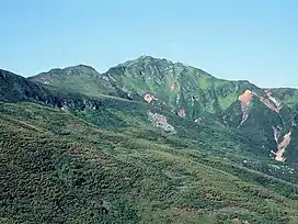 Mount Furano (July 2006) | |
| Highest point | |
| Elevation | 1,912.1 m (6,273 ft) |
| Listing | List of mountains and hills of Japan by height |
| Coordinates | 43°23′37″N 142°38′5″E / 43.39361°N 142.63472°E |
| Geography | |
| Location | Hokkaidō, Japan |
| Parent range | Tokachi Volcanic Group |
| Topo map | Geographical Survey Institute of Japan 25000:1 十勝岳 50000:1 十勝岳 |
| Geology | |
| Age of rock | Quaternary |
| Mountain type | stratovolcano |
| Volcanic arc/belt | Kuril arc |
Mount Furano (富良野岳, Furano-dake) is a mountain located in the Tokachi Volcanic Group, Hokkaidō, Japan.
See also
References
- Google Maps
- Geographical Survey Institute
- Paul Hunt, Hiking in Japan: An Adventurer's Guide to the Mountain Trails, Tokyo, Kodansha International Ltd., 1988. ISBN 0-87011-893-5 and ISBN 4-7700-1393-0 C0075
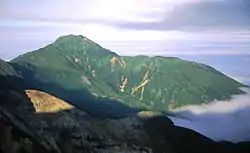
Mount Furano from Mount Tokachi
Wikimedia Commons has media related to Mount Furano.
This article is issued from Wikipedia. The text is licensed under Creative Commons - Attribution - Sharealike. Additional terms may apply for the media files.