al-Tall District
منطقة التل | |
|---|---|
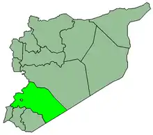
 Map of al-Tall District within Rif Dimashq Governorate | |
| Coordinates (al-Tall): 33°36′N 36°18′E / 33.6°N 36.3°E | |
| Country | |
| Governorate | Rif Dimashq |
| Seat | al-Tall |
| Subdistricts | 3 nawāḥī |
| Area | |
| • Total | 559.06 km2 (215.85 sq mi) |
| Population (2004)[1] | |
| • Total | 115,937 |
| • Density | 210/km2 (540/sq mi) |
| Geocode | SY0304 |
al-Tall District (Arabic: منطقة التل, romanized: manṭiqat al-Tall) is a district of the Rif Dimashq Governorate in southern Syria. The administrative centre is the city of al-Tall. At the 2004 census, the district had a population of 115,937.[1]
Sub-districts
The district of al-Tall is divided into three sub-districts or nawāḥī (population as of 2004[1]):
| Code | Name | Area | Population |
|---|---|---|---|
| SY030400 | al-Tall Subdistrict | 224.35 km² | 85,933 |
| SY030401 | Saidnaya Subdistrict | 138.01 km² | 18,846 |
| SY030402 | Rankous Subdistrict | 196.70 km² | 11,158 |
Localities in al-Tall District
According to the Central Bureau of Statistics (CBS), the following villages, towns and cities make up the district of al-Tall:[1]
| English Name | Arabic Name | Population | Subdistrict |
|---|---|---|---|
| al-Tall | التل | 44,597 | Al-Tall |
| Manin | منين | 17,521 | Al-Tall |
| Maaraba | معربا | 10,290 | Al-Tall |
| Rankous | رنكوس | 7,717 | Rankous |
| Badda | بدا | 6,564 | Saidnaya |
| Halboun | حلبون | 6,521 | Al-Tall |
| Saidnaya | صيدنايا | 5,194 | Saidnaya |
| Talfita | تلفيتا | 4,082 | Al-Tall |
| Hafeir al-Fouqa | حفير الفوقا | 3,441 | Saidnaya |
| Maarat Saidnaya | معرة صيدنايا | 3,084 | Saidnaya |
| Hosh Arab | حوش عرب | 2,073 | Rankous |
| al-Dreij | الدريج | 1,769 | Al-Tall |
| Maarounah | معرونة | 1,153 | Al-Tall |
| al-Fayadiyah | الفياضية | 785 | Rankous |
| Akoubar | عكوبر | 563 | Saidnaya |
| al-Jarniyah | الجرنية | 271 | Rankous |
| al-Mahabah | المحبة | 100 | Rankous |
| Sabnah | سبنة | 94 | Rankous |
| Ayn Dara | عين دره | 63 | Rankous |
| al-Nour | النور | 55 | Rankous |
References
- 1 2 3 4 "General Census of Population and Housing 2004" (PDF) (in Arabic). Syrian Central Bureau of Statistics. Archived from the original (PDF) on 8 December 2015. Retrieved 15 October 2015. Also available in English: "Syria: 2004 census data". UN OCHA. Retrieved 15 October 2015.
|   | ||||||||||||||||||
|
| |||||||||||||||||||
| |||||||||||||||||||
| |||||||||||||||||||
| |||||||||||||||||||
| |||||||||||||||||||
| |||||||||||||||||||
| |||||||||||||||||||
| |||||||||||||||||||
This article is issued from Wikipedia. The text is licensed under Creative Commons - Attribution - Sharealike. Additional terms may apply for the media files.