Albon-d'Ardèche | |
|---|---|
.JPG.webp) Albon d'Ardèche main street | |
Location of Albon-d'Ardèche | |
 Albon-d'Ardèche  Albon-d'Ardèche | |
| Coordinates: 44°49′20″N 4°25′43″E / 44.8222°N 4.4286°E | |
| Country | France |
| Region | Auvergne-Rhône-Alpes |
| Department | Ardèche |
| Arrondissement | Tournon-sur-Rhône |
| Canton | Haut-Eyrieux |
| Intercommunality | Val'Eyrieux |
| Government | |
| • Mayor (2020–2026) | Alain Baconnier[1] |
| Area 1 | 9.11 km2 (3.52 sq mi) |
| Population | 158 |
| • Density | 17/km2 (45/sq mi) |
| Time zone | UTC+01:00 (CET) |
| • Summer (DST) | UTC+02:00 (CEST) |
| INSEE/Postal code | 07006 /07190 |
| Elevation | 567–1,112 m (1,860–3,648 ft) (avg. 630 m or 2,070 ft) |
| 1 French Land Register data, which excludes lakes, ponds, glaciers > 1 km2 (0.386 sq mi or 247 acres) and river estuaries. | |
Albon-d'Ardèche (French pronunciation: [albɔ̃ daʁdɛʃ]; Occitan: Aubon d'Ardecha) is a commune in the Ardèche department in the Auvergne-Rhône-Alpes region of southern France.
The inhabitants of the commune are known as Albonnais or Albonnaises[3]
Geography
Albon-d'Ardèche is located some 25 km west of Livron-sur-Drome and about 30 km east of Langogne. The commune is traversed by the D102 coming east from Mézilhac through the village and continuing east to Saint-Sauveur-de-Montagut. The D211 also traverses the commune in the south running east from the D122 to Saint-Pierreville. Grand Feouzet in the south of the commune is accessed from this road via country roads. There is a considerable amount of forest in the commune and a little farming.[4]
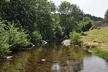
The Glueyre river passes through the commune from west to east fed by a number of streams in the commune. The river passes through the village and continues east to join the Eyrieux river at Saint-Sauveur-de-Montagut.[4]
Localities, villages and areas
- Féouzet (and Grand Féouzet)
- Serrepuy
- La Neuve
- Crouzet
- Ribier
- La Sauzée
- Pouchet
- Rouvier
- Le Priouret
- La Pra
- Rémus
- Le Fay
- La Grangette
- La Combe
- Le Pendey
- Tauzuc
Neighbouring communes and towns
Places adjacent to Albon-d'Ardèche | ||||||||||||||||
|---|---|---|---|---|---|---|---|---|---|---|---|---|---|---|---|---|
| ||||||||||||||||
History
The Communes of Albon d'Ardèche and Marcols-les-Eaux formed the village of Marcol until 1912.
Administration
List of Successive Mayors of Albon d'Ardèche[5]
| From | To | Name |
|---|---|---|
| 1912 | 1919 | Auguste Giraud |
| 1919 | 1923 | Elie Seauve |
| 1923 | 1929 | Marcel Magnan |
| 1929 | 1945 | Gaston Bonnet |
| 1945 | 1953 | Elie Berthaud |
| 1953 | 1958 | Gaston Bonnet |
| 1958 | 1975 | Albert Brotte |
| 1975 | 1983 | Fernand Flandrin |
| 1983 | 1989 | Louis Lextrait |
| 1989 | 1995 | Jean Louis Chirouze |
| 1995 | 1997 | Pierre Dumas |
| 1997 | 2000 | René Blache |
| 2000 | 2001 | Gisèle Nury |
| 2001 | 2010 | Michel Filippi |
| 2010 | 2020 | Frédéric Picard |
| 2020 | Current | Alain Baconnier |
Population
| Year | Pop. | ±% p.a. |
|---|---|---|
| 1968 | 276 | — |
| 1975 | 232 | −2.45% |
| 1982 | 180 | −3.56% |
| 1990 | 173 | −0.49% |
| 1999 | 165 | −0.52% |
| 2007 | 159 | −0.46% |
| 2012 | 159 | +0.00% |
| 2017 | 159 | +0.00% |
| Source: INSEE[6] | ||
Distribution of Age Groups
The population of the town is older than the departmental average.
Percentage Distribution of Age Groups in Albon-d'Ardèche and Ardèche Department in 2017
| Albon-d'Ardèche | Ardèche | |||
|---|---|---|---|---|
| Age Range | Men | Women | Men | Women |
| 0 to 14 Years | 12.2 | 10.1 | 17.7 | 16.1 |
| 15 to 29 Years | 14.4 | 11.6 | 14.4 | 13.0 |
| 30 to 44 Years | 15.6 | 13.0 | 17.3 | 16.9 |
| 45 to 59 Years | 25.6 | 33.3 | 21.6 | 20.7 |
| 60 to 74 Years | 21.1 | 8.7 | 19.7 | 19.7 |
| 75 to 89 Years | 8.9 | 21.7 | 8.5 | 11.2 |
| 90 Years+ | 2.2 | 1.4 | 0.9 | 2.4 |
Gallery
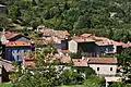 The east of the village
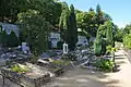 The Municipal Cemetery
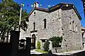 The Temple in the village
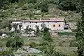 The Garnier Quarter
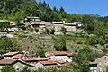 The Périchon Quarter
 An old house in the village
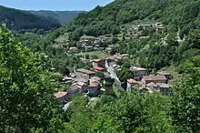
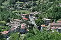 A General View of the village
 The summit of Serre de Champ Maux
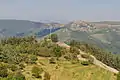 The Graveyre ancient volcano
.JPG.webp) The old Barry Mill
The old Barry Mill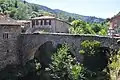 The bridge at Albon d'Ardèche
.JPG.webp) View of Grand Féouzet from the south
View of Grand Féouzet from the south The oven of Féouzet
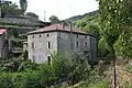 The old grinding mill at La Neuve
See also
References
- ↑ "Répertoire national des élus: les maires". data.gouv.fr, Plateforme ouverte des données publiques françaises (in French). 2 December 2020.
- ↑ "Populations légales 2021". The National Institute of Statistics and Economic Studies. 28 December 2023.
- ↑ Inhabitants of Ardèche (in French)
- 1 2 3 Google Maps
- ↑ List of Mayors of France (in French)
- 1 2 Évolution et structure de la population en 2017: Commune d'Albon-d'Ardèche (07006)
- ↑ Évolution et structure de la population en 2017: Département de l'Ardèche (07)
External links
- Albon-d'Ardèche official website Archived 2013-05-23 at the Wayback Machine (in French)
- Albon-d'Ardèche on the joint Inforoutes website (in French)
- Albon-d'Ardèche on the old National Geographic Institute website (in French)
- Albon-d'Ardèche on Géoportail, National Geographic Institute (IGN) website (in French)
- Albon on the 1750 Cassini Map