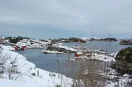
 Shoreline of Algrøyna | |
 Location of the island | |
| Geography | |
|---|---|
| Location | Vestland, Norway |
| Coordinates | 60°21′10″N 4°57′21″E / 60.3527°N 4.9558°E |
| Area | 4.9 km2 (1.9 sq mi) |
| Length | 3 km (1.9 mi) |
| Width | 3 km (1.9 mi) |
| Highest elevation | 78 m (256 ft) |
| Highest point | Hillefjellet |
| Administration | |
Norway | |
| County | Vestland |
| Municipality | Øygarden |
Algrøyna or Algrøy is an island in Øygarden Municipality in Vestland county, Norway. The 4.9-square-kilometre (1.9 sq mi) island lies just west of the large island of Sotra and north of the small island of Lokøyna. There are a series of bridges connecting it to the island of Sotra, which in turn is connected to the mainland. The highest point on the island is the 78-metre (256 ft) tall mountain Hillefjellet. Almost all the residents of the island live along the northern shore, in a village area that is referred to as Algrøyna.[1]
See also
References
- ↑ Store norske leksikon. "Algrøy" (in Norwegian). Retrieved 2014-12-01.
This article is issued from Wikipedia. The text is licensed under Creative Commons - Attribution - Sharealike. Additional terms may apply for the media files.