Aline Covered Bridge | |
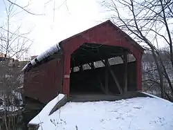 The bridge in 2013 | |
  | |
| Location | NW of Meiserville, Perry Townships, Meiserville, Pennsylvania |
|---|---|
| Coordinates | 40°40′35″N 76°58′46″W / 40.67639°N 76.97944°W |
| Area | 0.1 acres (0.040 ha) |
| Built | 1884 |
| Architectural style | Burr arch |
| MPS | Covered Bridges of Juniata and Snyder Counties TR |
| NRHP reference No. | 79002344[1] |
| Added to NRHP | August 10, 1979 |
The Aline Covered Bridge, also known as Meiserville Covered Bridge, is a historic covered bridge located in Perry Township near Meiserville in Snyder County, Pennsylvania. It is a 60-foot-long (18 m) Burr Truss bridge built in 1884. It crosses the North Branch of Mahantango Creek.[2]
In 1982 a new bridge was built to bypass the covered bridge, which is open only to pedestrian traffic. A round picnic table sits in the middle of the bridge.[3] It was listed on the National Register of Historic Places in 1979.[1]
See also
References
Wikimedia Commons has media related to Aline Covered Bridge.
- 1 2 "National Register Information System". National Register of Historic Places. National Park Service. March 13, 2009.
- ↑ Susan M. Zacher and Tobi Casner (February 1979). "National Register of Historic Places Inventory — Nomination Form: Covered Bridges of Juniata and Snyder Counties: Aline Covered Bridge" (PDF). Pennsylvania Historical and Museum Commission. Retrieved 2009-10-20.
- ↑ "Covered Bridge Tour of Snyder County, PA" (PDF). Snyder County, Pennsylvania. Retrieved November 22, 2013.

This article is issued from Wikipedia. The text is licensed under Creative Commons - Attribution - Sharealike. Additional terms may apply for the media files.