Anhiers | |
|---|---|
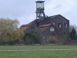 Former coal mine | |
_Nord-France.svg.png.webp) Coat of arms | |
Location of Anhiers | |
 Anhiers  Anhiers | |
| Coordinates: 50°24′27″N 3°09′24″E / 50.4075°N 3.1567°E | |
| Country | France |
| Region | Hauts-de-France |
| Department | Nord |
| Arrondissement | Douai |
| Canton | Orchies |
| Intercommunality | Douaisis Agglo |
| Government | |
| • Mayor (2020–2026) | Nadine Mortelette-Vahé[1] |
| Area 1 | 1.71 km2 (0.66 sq mi) |
| Population | 893 |
| • Density | 520/km2 (1,400/sq mi) |
| Time zone | UTC+01:00 (CET) |
| • Summer (DST) | UTC+02:00 (CEST) |
| INSEE/Postal code | 59007 /59194 |
| Elevation | 17–22 m (56–72 ft) (avg. 23 m or 75 ft) |
| 1 French Land Register data, which excludes lakes, ponds, glaciers > 1 km2 (0.386 sq mi or 247 acres) and river estuaries. | |
Anhiers is a commune in the Nord department in northern France.[3]
Population
| Year | Pop. | ±% p.a. |
|---|---|---|
| 1968 | 780 | — |
| 1975 | 754 | −0.48% |
| 1982 | 687 | −1.32% |
| 1990 | 954 | +4.19% |
| 1999 | 985 | +0.36% |
| 2009 | 976 | −0.09% |
| 2014 | 927 | −1.02% |
| 2020 | 892 | −0.64% |
| Source: INSEE[4] | ||
Heraldry
Arms of Anhiers |
The arms of Anhiers are blazoned : Per fess Or and azure, 3 fleurs de lys counterchanged. (Anhiers and Merville use the same arms.)
|
See also
References
- ↑ "Répertoire national des élus: les maires". data.gouv.fr, Plateforme ouverte des données publiques françaises (in French). 2 December 2020.
- ↑ "Populations légales 2021". The National Institute of Statistics and Economic Studies. 28 December 2023.
- ↑ INSEE commune file
- ↑ Population en historique depuis 1968, INSEE
Wikimedia Commons has media related to Anhiers.
This article is issued from Wikipedia. The text is licensed under Creative Commons - Attribution - Sharealike. Additional terms may apply for the media files.