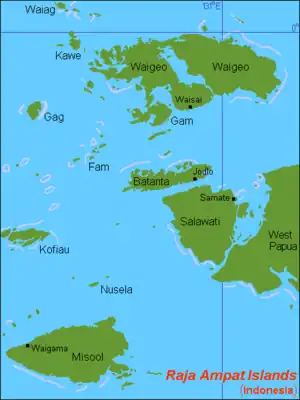
 Location of the Ayu islands, labelled as Ayau here, just north of Waigeo in the Raja Ampat Islands, Southwest Papua, Indonesia | |
| Geography | |
|---|---|
| Location | South East Asia |
| Coordinates | 0°22′N 131°02′E / 0.367°N 131.033°E |
| Archipelago | Raja Ampat Islands |
| Total islands | 5 (2 uninhabited) |
| Major islands | Pulau Ayu, Pulau Reni, Pulau Kanobe |
| Highest elevation | 106 m (348 ft) |
| Administration | |
| Province | Southwest Papua |
| Demographics | |
| Ethnic groups | Melanesians, Papuans, Austronesians |
The Ayu Islands (Kepulauan Ayu), are a small archipelago south of the Asia Islands and north of Raja Ampat Islands in Indonesia. This group is formed by two coral atolls. The highest point is 106 m.[1]
In older maps these islands appear as the Ajoe Islands, following the Dutch spelling "Ajoe-eilanden".
The beaches of these islands are a breeding ground for the leatherback turtle (Dermochelys coriacea). The waters off the Ayu Islands are a good snorkeling and scuba diving site.
Administratively the Ayu Islands belong to the Indonesian province of Southwest Papua.
References
- ↑ Pub164, 2004 Sailing Directions (Enroute): New Guinea
Administrative Region: Southwest Papua | ||
| Islands | ||
This article is issued from Wikipedia. The text is licensed under Creative Commons - Attribution - Sharealike. Additional terms may apply for the media files.