| Azergues | |
|---|---|
 | |
 | |
| Location | |
| Country | France |
| Physical characteristics | |
| Mouth | |
• location | Saône |
• coordinates | 45°56′30″N 4°43′45″E / 45.94167°N 4.72917°E |
| Length | 62 km (39 mi) |
| Basin size | 886 km2 (342 sq mi) |
| Discharge | |
| • average | 75 m3/s (2,600 cu ft/s) |
| Basin features | |
| Progression | Saône→ Rhône→ Mediterranean Sea |
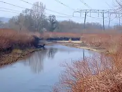
The Azergues (French pronunciation: [azɛʁɡ]) is a river in the department of Rhône, eastern France. It is a right tributary of the Saône, which it joins in Anse. It is 62.4 km (38.8 mi) long.[1] Its source is in the Beaujolais hills, near Chénelette. The Azergues flows through the following towns: Lamure-sur-Azergues, Le Bois-d'Oingt, Chessy, Châtillon, Chazay-d'Azergues and Anse.[1]
Etymology
It has been suggested that the name Azergues comes from the Arabic "Azraq" (أزرق), which means blue.[2]
References
This article is issued from Wikipedia. The text is licensed under Creative Commons - Attribution - Sharealike. Additional terms may apply for the media files.