Berezove
Березове | |
|---|---|
Village | |
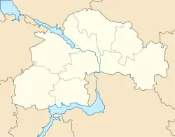 Berezove Location of Berezove within Ukraine  Berezove Berezove (Ukraine) | |
| Coordinates: 47°52′25″N 36°29′47″E / 47.87361°N 36.49639°E | |
| Country | |
| Oblast | Dnipropetrovsk Oblast |
| Raion | Synelnykove Raion |
| Village Council | Berezove Village Council |
| Based | 1921 |
| Area | |
| • Total | 0.131 km2 (0.051 sq mi) |
| Elevation | 147 m (482 ft) |
| Population | |
| • Total | 585 |
| • Density | 4,465.65/km2 (11,566.0/sq mi) |
| 53624 | Zip Code |
| Telephone Code | +380 5638 |
Berezove (Ukrainian: Березове) is a village in the Synelnykove Raion of the Dnipropetrovsk Oblast, Ukraine. It has a population of 585 people.
Geography
The village is located in the Synelnykove Raion, formed from the abolishement of the Pokrovsky Raion,[1] in east Ukraine. The village is located near the tri-point border of Dnipropetrovsk, Donetsk and Zaporizhzhia Oblasts, close to the villages of Novopil, Ternove and Maliivka. The altitude is 147 meters.[2]
History
The village was founded in 1921.
In 2022, the village was contested in the early months of the Russian invasion of Ukraine.[3]
References
- ↑ "Про утворення та ліквідацію районів". Офіційний вебпортал парламенту України (in Ukrainian). Retrieved 2023-04-08.
- ↑ "weather.in.ua - погода в с. Березове (Дніпропетровська область, Покровський район) - прогноз погоди в Україні на 3 та 5 днів". weather.in.ua. Retrieved 2023-04-08.
- ↑ "Держспецзв'язку". Telegram. Retrieved 2023-04-08.
47°52′27″N 36°29′38″E / 47.87417°N 36.49389°E
This article is issued from Wikipedia. The text is licensed under Creative Commons - Attribution - Sharealike. Additional terms may apply for the media files.