| Bormida di Spigno | |
|---|---|
 The river in Cairo Montenotte | |
 | |
| Location | |
| Country | Italy |
| Physical characteristics | |
| Source | |
| • location | Pian dei Corsi, Liguria |
| • elevation | 1,000 m (3,300 ft) |
| Mouth | |
• location | Bormida, near Bistagno (AL) |
• coordinates | 44°39′27″N 8°21′10″E / 44.6575°N 8.3528°E |
| Length | 58.2 km (36.2 mi)[1] |
| Basin size | 273.7 km2 (105.7 sq mi)[2] |
| Discharge | |
| • average | 6.7 m3/s (240 cu ft/s)[2] |
| Basin features | |
| Progression | Bormida→ Tanaro→ Po→ Adriatic Sea |
The Bormida di Spigno is a river of north-west Italy.
Geography
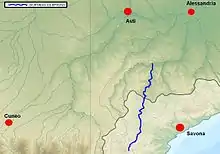
The headwaters of the Bormida di Spigno are in the Ligurian province of Savona above Pian dei Corsi at 1,000 metres (3,300 ft) above sea level in a transitional zone between the Alpine and Apennine mountain ranges. There its waters run as the separate “Bormidas” of Mallare and Pallare in distinct close valleys before quickly joining after a few kilometers. It joins with the Bormida (or Bormida di Millesimo) near Bistagno in the Piedmontese province of Alessandria.
References
- ↑ AA.VV. "Elaborato I.c/5". Piano di Tutela delle Acque - Revisione del 1º luglio 2004; Caratterizzazione bacini idrografici (PDF) (in Italian). Regione Piemonte. Archived from the original (PDF) on 2012-02-25. Retrieved 2016-07-27.
- 1 2 AA.VV. "Elaborato I.c/7". Piano di Tutela delle Acque - Revisione del 1º luglio 2004; Caratterizzazione bacini idrografici (PDF) (in Italian). Regione Piemonte. Archived from the original (PDF) on 2016-03-03. Retrieved 2016-07-27.
![]() Media related to Bormida di Spigno at Wikimedia Commons
Media related to Bormida di Spigno at Wikimedia Commons
This article is issued from Wikipedia. The text is licensed under Creative Commons - Attribution - Sharealike. Additional terms may apply for the media files.