Bourg-Archambault | |
|---|---|
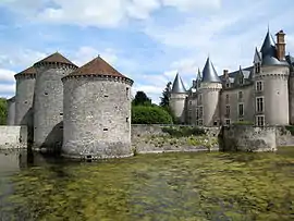 The Chateau of Bourg-Archambault | |
Location of Bourg-Archambault | |
 Bourg-Archambault  Bourg-Archambault | |
| Coordinates: 46°23′39″N 1°00′15″E / 46.3942°N 1.0042°E | |
| Country | France |
| Region | Nouvelle-Aquitaine |
| Department | Vienne |
| Arrondissement | Montmorillon |
| Canton | Montmorillon |
| Government | |
| • Mayor (2020–2026) | Bernard Richefort[1] |
| Area 1 | 24.33 km2 (9.39 sq mi) |
| Population | 176 |
| • Density | 7.2/km2 (19/sq mi) |
| Time zone | UTC+01:00 (CET) |
| • Summer (DST) | UTC+02:00 (CEST) |
| INSEE/Postal code | 86035 /86390 |
| Elevation | 123–201 m (404–659 ft) (avg. 206 m or 676 ft) |
| 1 French Land Register data, which excludes lakes, ponds, glaciers > 1 km2 (0.386 sq mi or 247 acres) and river estuaries. | |
Bourg-Archambault (French pronunciation: [buʁ aʁʃɑ̃bo]) is a commune in the Vienne department in the Nouvelle-Aquitaine region in western France.
Bourg-Archambault has a privately owned chateau of special architectural interest: consisting of a four turreted 'keep' style building which was renovated during 2003: surrounded by a moat and having an entrance bridge and what appears to be a drawbridge tower
Geography
The Salleron forms parts of the commune's western border, then flows northward through its northern part.
See also
References
- ↑ "Répertoire national des élus: les maires". data.gouv.fr, Plateforme ouverte des données publiques françaises (in French). 2 December 2020.
- ↑ "Populations légales 2021". The National Institute of Statistics and Economic Studies. 28 December 2023.
Wikimedia Commons has media related to Bourg-Archambault.
This article is issued from Wikipedia. The text is licensed under Creative Commons - Attribution - Sharealike. Additional terms may apply for the media files.