Canoe | |
|---|---|
 Canoe Location within the state of Kentucky  Canoe Canoe (the United States) | |
| Coordinates: 37°26′56″N 83°26′55″W / 37.44889°N 83.44861°W | |
| Country | United States |
| State | Kentucky |
| County | Breathitt |
| Elevation | 718 ft (219 m) |
| Time zone | UTC-5 (Eastern (EST)) |
| • Summer (DST) | UTC-4 (EDT) |
| ZIP codes | 41316 |
| GNIS feature ID | 511206[1] |
Canoe is an unincorporated community located in Breathitt County, Kentucky, United States. Its post office closed in 1993.[2]
The origin of the name Canoe is unclear. According to legend, at one point waters were so shallow on nearby Canoe Creek, a canoe had to be abandoned.[3]
References
- ↑ U.S. Geological Survey Geographic Names Information System: Canoe, Kentucky
- ↑ http://webpmt.usps.gov/pmt007.cfm. Retrieved July 30, 2012.
{{cite web}}: Missing or empty|title=(help) - ↑ Rennick, Robert M. (1987). Kentucky Place Names. University Press of Kentucky. p. 49. ISBN 978-0813126319. Retrieved April 28, 2013.
Municipalities and communities of Breathitt County, Kentucky, United States | ||
|---|---|---|
| City | 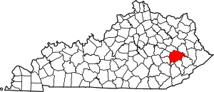 Location of Breathitt County, Kentucky | |
| Unincorporated communities | ||
| post offices (and the creeks they are on) |
| |
| towns | ||
| Footnotes | ‡This post office is strictly speaking in Perry County even though the Creek is mainly in Breathitt. | |
This article is issued from Wikipedia. The text is licensed under Creative Commons - Attribution - Sharealike. Additional terms may apply for the media files.