| Cerro Lípez | |
|---|---|
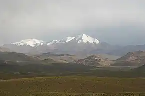 Cerro Lípez as seen from the north. | |
| Highest point | |
| Elevation | 5,933 m (19,465 ft)[1] |
| Coordinates | 21°54′51″S 66°53′05″W / 21.91417°S 66.88472°W |
| Geography | |
| Location | Sud Lípez province, Potosí Department, Bolivia |
| Parent range | Cordillera de Lípez |
| Geology | |
| Mountain type | stratovolcano |

Landsat view of Cerro Lípez, with pin
Cerro Lípez (also Cerro Lipez) is a stratovolcano in the Cordillera de Lípez in the Sud Lípez Province of the Potosí Department in southwestern Bolivia. It has twin peaks and rises to 5,933 m. On some maps[2] it is incorrectly labeled as Nuevo Mundo. Nuevo Mundo is in fact hundreds of kilometres to the northeast and five hundred metres shorter. The confusion came in part from a misidentification of the height of Nuevo Mundo.[3]
See also
Notes
- ↑ BIGM map 1:50.000 San Antonio de Lípez 6228-III
- ↑ "Map of Nuevo Mundo location". Bing Maps. Archived from the original on 10 May 2012.
- ↑ Brain, Yossi (1999). "Climbs and Expeditions: Bolivia: Cordillera Sud Lipez" (PDF). American Alpine Journal: 322–323, page 323. Archived from the original (PDF) on 26 April 2005.
This article is issued from Wikipedia. The text is licensed under Creative Commons - Attribution - Sharealike. Additional terms may apply for the media files.