Chute-Saint-Philippe | |
|---|---|
 | |
 Location within Antoine-Labelle RCM | |
 Chute-Saint-Philippe Location in central Quebec | |
| Coordinates: 46°39′N 75°14′W / 46.650°N 75.233°W[1] | |
| Country | Canada |
| Province | Quebec |
| Region | Laurentides |
| RCM | Antoine-Labelle |
| Constituted | October 26, 1940 |
| Government | |
| • Mayor | Normand St-Amour |
| • Federal riding | Laurentides—Labelle |
| • Prov. riding | Labelle |
| Area | |
| • Total | 322.00 km2 (124.32 sq mi) |
| • Land | 298.64 km2 (115.31 sq mi) |
| Population (2021)[3] | |
| • Total | 1,039 |
| • Density | 3.5/km2 (9/sq mi) |
| • Pop. 2016-2021 | |
| • Dwellings | 876 |
| Time zone | UTC−5 (EST) |
| • Summer (DST) | UTC−4 (EDT) |
| Postal code(s) | |
| Area code | 819 |
| Highways | |
| Website | www |
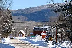
Chute-Saint-Philippe is a municipality in the Laurentides region of Quebec, Canada, part of the Antoine-Labelle Regional County Municipality.
The village is located in a fairly flat valley surrounded by a mountainous area of the Laurentian Hills that are dominated by mixed forest.[1]
History
The settlement initially had the name Chute-Leon at the beginning of the 20th century, in memory of Pope Leo XIII (1810-1903), and was called Victoria Falls by 1903, in honour of Queen Victoria (1819-1901).[1]
In 1921, a mission was founded here with Philip the Apostle as its patron saint. In 1934, the local post office was renamed to Chute-Saint-Philippe, taking its name from a drop on the Kiamika River and the patron saint.[1] On December 26, 1940, the Municipality of Chute St-Philippe was formed out of territory ceded from Ferme-Neuve and an adjacent unorganized territory. In 1969, the orthography was adjusted to Chute-Saint-Philippe.[4]
In 1966, the mission received its status as a parish.[1]
Demographics
| Year | Pop. | ±% |
|---|---|---|
| 1976 | 453 | — |
| 1981 | 610 | +34.7% |
| 1986 | 602 | −1.3% |
| 1991 | 698 | +15.9% |
| 1996 | 778 | +11.5% |
| 2001 | 823 | +5.8% |
| 2006 | 890 | +8.1% |
| 2011 | 892 | +0.2% |
| 2016 | 942 | +5.6% |
| 2021 | 1,039 | +10.3% |
| Source: Statistics Canada | ||
In the 2021 Census of Population conducted by Statistics Canada, Chute-Saint-Philippe had a population of 1,039 living in 513 of its 876 total private dwellings, a change of 10.3% from its 2016 population of 942. With a land area of 298.64 km2 (115.31 sq mi), it had a population density of 3.5/km2 (9.0/sq mi) in 2021.[5]
Mother tongue:
- English as first language: 1.9%
- French as first language: 95.2%
- English and French as first language: 1.4%
- Other as first language: 1.4%
Local government
| Year | Liberal | Conservative | Bloc Québécois | New Democratic | Green | ||||||
|---|---|---|---|---|---|---|---|---|---|---|---|
| 2021 | 19% | 115 | 16% | 94 | 55% | 327 | 3% | 19 | 2% | 10 | |
| 2019 | 31% | 167 | 8% | 42 | 52% | 276 | 5% | 27 | 3% | 16 | |
| Year | CAQ | Liberal | QC solidaire | Parti Québécois | |||||
|---|---|---|---|---|---|---|---|---|---|
| 2018 | 37% | 221 | 9% | 52 | 13% | 79 | 38% | 228 | |
| 2014 | 23% | 144 | 22% | 135 | 8% | 51 | 45% | 281 | |
Chute-Saint-Philippe forms part of the federal electoral district of Laurentides—Labelle and has been represented by Marie-Hélène Gaudreau of the Bloc Québécois since 2019. Provincially, Chute-Saint-Philippe is part of the Labelle electoral district and is represented by Chantale Jeannotte of the Coalition Avenir Québec since 2018.
List of former mayors:[8]
- Heni Jolicoeur (1941–1967)
- Arnold Michaudville (1967–1971)
- Jean-Pierre Jolicoeur (1971–1973)
- Georges Bélec (1973–1975)
- Fernand Prud'Homme (1975–1978)
- Jacques Perras (1978–1981)
- Francine Bélec (interim 1981)
- Jean-Pierre Jolicoeur (1981–1995)
- Henriette Lachaine (1995–1997)
- Jean-Jacques Paquette (1997–2005)
- Claude Blain (2005–2009)
- Normand St-Amour (2009–present)
See also
References
- 1 2 3 4 5 "Chute-Saint-Philippe (Municipalité)" (in French). Commission de toponymie du Québec. Retrieved 2009-08-26.
- 1 2 "Répertoire des municipalités: Geographic code 79065". www.mamh.gouv.qc.ca (in French). Ministère des Affaires municipales et de l'Habitation.
- 1 2 "Chute-Saint-Philippe, Municipalité (MÉ) Census Profile, 2021 Census of Population". www12.statcan.gc.ca. Government of Canada - Statistics Canada. Retrieved 27 June 2022.
- ↑ "Répertoire des entités géopolitiques: Chute-Saint-Philippe (municipalité) 26.10.1940 - ..." www.mairesduquebec.com. Institut généalogique Drouin. Retrieved 27 June 2022.
- ↑ "Population and dwelling counts: Canada, provinces and territories, and census subdivisions (municipalities), Quebec". Statistics Canada. February 9, 2022. Retrieved August 29, 2022.
- ↑ "Official Voting Results Raw Data (poll by poll results in block 1628)". Elections Canada. Retrieved March 4, 2023.
- ↑ "Official Voting Results by polling station (poll by poll results in block 1628)". Elections Québec. Retrieved March 4, 2023.
- ↑ "Vie municipale: Historique". www.chute-saint-philippe.ca (in Canadian French). Municipalité de Chute-Saint-Philippe. Retrieved 27 June 2022.
External links
 Media related to Chute-Saint-Philippe at Wikimedia Commons
Adjacent Municipal Subdivisions | ||||||||||||||||
|---|---|---|---|---|---|---|---|---|---|---|---|---|---|---|---|---|
| ||||||||||||||||
| Cities/towns | |
|---|---|
| Municipalities | |
| Villages | |
| Unorganized territories | |
| |