| Cnicht North Top | |
|---|---|
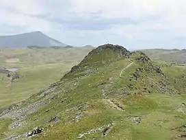 Cnicht North Top from Cnicht summit ridge | |
| Highest point | |
| Elevation | 688 m (2,257 ft) |
| Prominence | 18 m (59 ft) |
| Listing | Nuttall |
| Naming | |
| English translation | knight |
| Language of name | Old English |
| Pronunciation | Welsh pronunciation: [ˈknɪχt] |
| Geography | |
| Location | Gwynedd, Wales |
| Parent range | Moelwynion |
| OS grid | SH645466 |
| Topo map | OS Landranger 115 |
Cnicht North Top is a top of Cnicht in Snowdonia, which forms part of the Moelwynion mountain range.
It is one of the Nuttalls,[1] a list of 443 hills in England and Wales over 2,000 ft (610 m) with a relative height of at least 49 ft (15 m). The list was compiled by John and Anne Nuttall and published in 1993 as two volumes, "The Mountains of England & Wales".[2]
North Top is a bump on the north ridge; it is often bypassed by walkers heading for Ysgafell Wen, Moel Druman and Allt-fawr.
Height in Metres: 688 metres[3]
References
- ↑ "UKC Logbook - Nuttalls". www.ukclimbing.com.
- ↑ Nuttall, John & Anne (1999). The Mountains of England & Wales - Volume 1: Wales (2nd edition ed.). Milnthorpe, Cumbria: Cicerone. ISBN 1-85284-304-7.
- ↑ "Cnicht North Top | Summit | Mud and Routes | Gwynedd, Highest Mountains and Hills in Wales, Moelwynion". Mud and Routes. Retrieved 13 September 2021.
External links
53°0′1.26″N 4°1′7.66″W / 53.0003500°N 4.0187944°W
This article is issued from Wikipedia. The text is licensed under Creative Commons - Attribution - Sharealike. Additional terms may apply for the media files.