Eesterga
Jistergea | |
|---|---|
Village | |
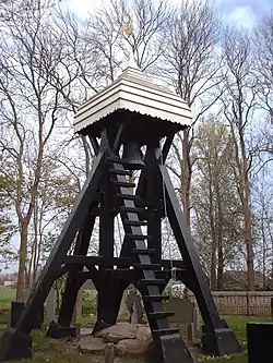 Eesterga Bell Tower | |
 Location in the former Lemsterlân municipality | |
 Eesterga Location in the Netherlands  Eesterga Eesterga (Netherlands) | |
| Coordinates: 52°51′53″N 5°43′34″E / 52.86472°N 5.72611°E | |
| Country | |
| Province | |
| Municipality | |
| Area | |
| • Total | 3.72 km2 (1.44 sq mi) |
| Elevation | −0.5 m (−1.6 ft) |
| Population (2021)[1] | |
| • Total | 45 |
| • Density | 12/km2 (31/sq mi) |
| Postal code | 8534[1] |
| Dialing code | 0514 |
Eesterga (West Frisian: Jistergea) is a small village in De Fryske Marren in the province of Friesland, the Netherlands. It had a population of around 45 in 2017.[3]
History
The village was first mentioned in 1505 as Eestergae. The etymology is unclear.[4] It used to have a church, but it was demolished in 1740. In 1840, it was home to 143 people.[5]
Before 2014 it was part of the Lemsterland municipality.[5]
Gallery
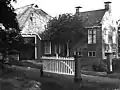 Farm in Eesterga
 Farm in Eesterga
References
- 1 2 3 "Kerncijfers wijken en buurten 2021". Central Bureau of Statistics. Retrieved 29 March 2022.
- ↑ "Postcodetool for 8534WB". Actueel Hoogtebestand Nederland (in Dutch). Het Waterschapshuis. Retrieved 29 March 2022.
- ↑ Kerncijfers wijken en buurten 2017 - CBS
- ↑ "Eesterga - (geografische naam)". Etymologiebank (in Dutch). Retrieved 29 March 2022.
- 1 2 "Eesterga". Plaatsengids (in Dutch). Retrieved 29 March 2022.
Wikimedia Commons has media related to Eesterga.
This article is issued from Wikipedia. The text is licensed under Creative Commons - Attribution - Sharealike. Additional terms may apply for the media files.