| Geitlandsjökull | |
|---|---|
 Geitlandsjökull Location in Iceland | |
| Highest point | |
| Elevation | 1,400 m (4,600 ft) |
| Coordinates | 64°36′00″N 20°36′00″W / 64.60000°N 20.60000°W |
| Geography | |
| Location | Iceland |
| Geology | |
| Mountain type | Tuya |
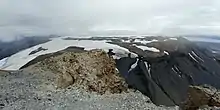
Geitlandsjökull as seen from adjacent Prestahnúkur to the east.
Geitlandsjökull (Icelandic pronunciation: [ˈceitˌlan(t)sˌjœːkʏtl̥] ⓘ) is a lateral glacier of Langjökull, the second largest ice cap in Iceland (953 km2), in the west of Iceland. The highest point of Geitlandsjökull, which lies on top of a tuya, reaches a height of 1,400 m.[1][2]
References
- ↑ Archived November 14, 2009, at the Wayback Machine
- ↑ Beleg 2009 durch Untersuchungen des Isl. Wetteramtes an Erdbebenserien Archived March 3, 2016, at the Wayback Machine
This article is issued from Wikipedia. The text is licensed under Creative Commons - Attribution - Sharealike. Additional terms may apply for the media files.