Gratwein | |
|---|---|
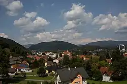 | |
 Coat of arms | |
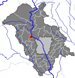 Location within Graz-Umgebung district | |
 Gratwein Location within Austria | |
| Coordinates: 47°07′46″N 15°19′04″E / 47.12944°N 15.31778°E | |
| Country | Austria |
| State | Styria |
| District | Graz-Umgebung |
| Government | |
| • Mayor | Adolf Egger (SPÖ) |
| Area | |
| • Total | 4.55 km2 (1.76 sq mi) |
| Elevation | 392 m (1,286 ft) |
| Population (2014-01-01) | |
| • Total | 3,664 |
| • Density | 810/km2 (2,100/sq mi) |
| Time zone | UTC+1 (CET) |
| • Summer (DST) | UTC+2 (CEST) |
| Postal code | 8112 |
| Area code | 03124 |
| Vehicle registration | GU |
| Website | www.gratwein.at |
Gratwein (German: [ɡʁatˈvaɪn]) was a municipality of Austria, merged in 2015 to form Gratwein-Straßengel in the district of Graz-Umgebung in the Austrian state of Styria.[1]
Population
| Year | Pop. | ±% |
|---|---|---|
| 1869 | 721 | — |
| 1880 | 793 | +10.0% |
| 1890 | 1,182 | +49.1% |
| 1900 | 1,299 | +9.9% |
| 1910 | 1,499 | +15.4% |
| 1923 | 1,497 | −0.1% |
| 1934 | 1,665 | +11.2% |
| 1939 | 1,754 | +5.3% |
| 1951 | 2,083 | +18.8% |
| 1961 | 2,515 | +20.7% |
| 1971 | 2,758 | +9.7% |
| 1981 | 3,108 | +12.7% |
| 1991 | 3,272 | +5.3% |
| 2001 | 3,525 | +7.7% |
| 2014 | 3,664 | +3.9% |
References
- ↑ Steiermärkisches Gemeindestrukturreformgesetz – StGsrG, Landesgesetzblatt des Landes Steiermark. Nr. 31/2014 (Styria State Official Gazette, in German).
This article is issued from Wikipedia. The text is licensed under Creative Commons - Attribution - Sharealike. Additional terms may apply for the media files.