| Gurnard | |
|---|---|
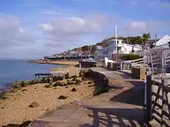 Gurnard beachfront | |
 Gurnard Location within the Isle of Wight | |
| Area | 4.0863 km2 (1.5777 sq mi) [1] |
| Population | 1,682 (2011 census including Rew Street)[2] |
| • Density | 412/km2 (1,070/sq mi) |
| OS grid reference | SZ478946 |
| Civil parish |
|
| Unitary authority | |
| Ceremonial county | |
| Region | |
| Country | England |
| Sovereign state | United Kingdom |
| Post town | COWES |
| Postcode district | PO31 |
| Dialling code | 01983 |
| Police | Hampshire and Isle of Wight |
| Fire | Hampshire and Isle of Wight |
| Ambulance | Isle of Wight |
| UK Parliament | |
Gurnard is a village and civil parish[3] on the Isle of Wight, two miles to the west of Cowes. Gurnard sits on the edge of Gurnard Bay, enjoyed by the Gurnard Sailing Club.
Gurnard's main street features a pub (Portland Inn), a few shops and a few houses. The west end of the beach is Gurnard Marsh and a stream called "The Luck" which discharges into the Solent.
A fortification known as Gurnard Fort was built on a headland west of Gurnard Marsh about 1600. The land was eroded, however, and all traces disappeared until an archaeological excavation of a Roman villa in 1864 uncovered traces of Gurnard Fort as well.[4]
Transport is provided by Southern Vectis route 32 to and from Cowes, and route 1 to Cowes and Newport, Isle of Wight.[5]
See also
References
- ↑ Office of National Statistics: QS102EW - Population density Archived 10 January 2020 at the Wayback Machine retrieved 30 May 2017
- ↑ "Civil Parish population 2011". Archived from the original on 20 January 2016. Retrieved 19 October 2015.
- ↑ "English Parishes & Welsh Communities N&C 2004". Archived from the original on 9 January 2007. Retrieved 30 March 2021.
- ↑ "Minor Fortifications of the Isle of Wight". Archived from the original on 22 July 2012., Rob Martin, March 2006
- ↑ Isle of Wight Council press release - "IW Council Steps In To Preserve Bus Routes" Archived 21 September 2008 at the Wayback Machine Accessed 31 August 2008.
External links
- Gurnard Sailing Club website
- Isle of Wight Council information
- Doughty Newnham Chartered Surveyors website
- Photos, accommodation guide, hotels and tourist information
- Gurnard Parish website and information
Wikimedia Commons has media related to Gurnard, Isle of Wight.
| Unitary authorities | |
|---|---|
| Major settlements (cities in italics) | |
| Rivers | |
| Topics | |
This article is issued from Wikipedia. The text is licensed under Creative Commons - Attribution - Sharealike. Additional terms may apply for the media files.