Hwango-dong | |
|---|---|
| Korean transcription(s) | |
| • Hangul | 황오동 |
| • Hanja | 皇吾洞 |
| • Revised Romanization | Hwango-dong |
| • McCune–Reischauer | Hwango-tong |
 | |
| Coordinates: 35°50′34″N 129°13′05″E / 35.84285°N 129.21792°E | |
| Country | South Korea |
| Region | Gyeongju |
| Government | |
| • Type | Gyeongju City |
| Area | |
| • Total | 1.5 km2 (0.6 sq mi) |
| Population (2008) | |
| • Total | 10,225 |
| • Density | 6,800/km2 (18,000/sq mi) |
| Dialect | Gyeongsang dialect |
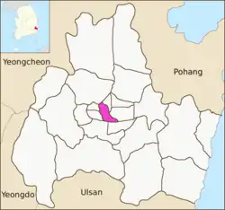
Hwango-dong is a dong or a neighbourhood of the Gyeongju City, North Gyeongsang province, South Korea. It is located in the central Gyeongju and is bordered by Bohwang-dong on the east, Jangang-dong on the west, Hwangnam-dong on the south and Seongdong-dong on the north. Its 1.5 square kilometers are home to about 10225 people. It is both an administrative dong and legal dong.[1]
The city's main railway station was located in the district. Hwango-dong has a middle school and a high school.[2]
See also
References
- ↑ "황오동 Hwango-dong 皇吾洞" (in Korean). Doosan Encyclopedia. Retrieved 2009-08-18.
- ↑ 교육기관 [Educational institution] (in Korean). Gyeongju City. Retrieved 2009-08-17.
External links
- (in Korean) The official site of the Hwango-dong office
4 eup, 8 myeon, 11 dong | ||
| Eup (town) |  | |
| Myeon (township) | ||
| Dong (neighborhood) | ||
| See also | ||
Website: www.gyeongju.go.kr | ||
This article is issued from Wikipedia. The text is licensed under Creative Commons - Attribution - Sharealike. Additional terms may apply for the media files.