| Jebel Kelti | |
|---|---|
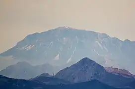 View of Jebel Kelti | |
| Highest point | |
| Elevation | 1,926 m (6,319 ft)[1] |
| Coordinates | 35°21′N 05°16′W / 35.350°N 5.267°W |
| Geography | |
 Jebel Kelti | |
| Parent range | Rif |
| Geology | |
| Age of rock | Paleozoic |
| Mountain type | Limestone-dolomite |
| Climbing | |
| First ascent | Unknown |
| Easiest route | From Chefchaouen |
Jebel Kelti is a mountain in the Tanger-Tetouan-Al Hoceima region, Morocco. It is located south of Tetouan in Chefchaouen Province. This mountain is part of the Rif mountain chain.
Description
Jebel Kelti is a limestone mountain, one of the highest in the Rif range with an elevation of about 1912 metres.[2] It is located between Tetouan and Chefchaouen in the Tanger-Tetouan-Al Hoceima region of Morocco. It has steep sides and a small summit area that offers a panoramic view of the surrounding region. There are some well-preserved cedar forests on its slopes.[3]
References
- ↑ Ahmed El Gharabaoui L'homme et la montagne dans la dorsale calcaire du Rif (Maroc septentrional)
- ↑ Jebel Kelti, Geonames.org, accessed 11 August 2012
- ↑ "Chefchaouen: tourisme et loisir". Archived from the original on 2018-12-15. Retrieved 2014-08-25.
External links
 Media related to Jebel Kelti at Wikimedia Commons
- Fiche technique de la randonnée à jbel Kelti dans la région Tetouan-Chefchaouen Archived 2013-08-24 at the Wayback Machine
- Ecotourism in Jbel Kelti - Chefchaouen - Morocco
- Gite d'Etape Ihettachene Jbel Kelti Tetouan مأوى إحتاشن
| High Atlas |
|
|---|---|
| Middle Atlas |
|
| Anti-Atlas |
|
| Saharan Atlas |
|
| Rif |
|
| Other peaks & ranges |
|
This article is issued from Wikipedia. The text is licensed under Creative Commons - Attribution - Sharealike. Additional terms may apply for the media files.