| Joderhorn | |
|---|---|
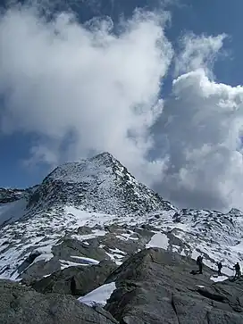 Joderhorn seen from Monte Moro Pass | |
| Highest point | |
| Elevation | 3,036 m (9,961 ft) |
| Prominence | 190 m (620 ft) |
| Isolation | 2.03 km (1.26 mi) |
| Geography | |
| Location | Piedmont, Italy Valais, Switzerland |
| Parent range | Pennine Alps |
The Joderhorn is a mountain of the Pennine Alps, with an elevation of 3,036 metres (9,961 ft), located on the border between Italy and Switzerland.[1][2][3]
Lying south-east of Monte Moro, the Joderhorn is on the boundary between the municipalities of Macugnaga in the Italian Province of Verbano-Cusio-Ossola and Saas Almagell in the Swiss Canton Valais, and can be reached from the Monte Moro Pass.[1][2][3]
References
- 1 2 "peakware.com/peaks.php?pk=589". peakware.com. Retrieved 2023-12-31.
- 1 2 "Joderhorn". Peakbagger.com. Retrieved 2023-12-31.
- 1 2 Draxler, A.; Alpen-Club, S. (1997). Alpenvereinshütten: Westalpen : Schutzhütten in der Schweiz, in Italien und in Frankreich ; 1064 Schutzhütten und Biwakschachteln des CAF, CAI, SAC, NFS sowie zahlreicher anderer alpiner Vereinigungen und privater Bewirtschafter. Bergverl. Rother. p. 248. ISBN 9783763380916. Retrieved 2023-12-31.
This article is issued from Wikipedia. The text is licensed under Creative Commons - Attribution - Sharealike. Additional terms may apply for the media files.