Körösszegapáti
Apateu | |
|---|---|
| Country | |
| County | Hajdú-Bihar |
| Area | |
| • Total | 45.85 km2 (17.70 sq mi) |
| Population (2015) | |
| • Total | 1,012[1] |
| • Density | 22.1/km2 (57/sq mi) |
| Time zone | UTC+1 (CET) |
| • Summer (DST) | UTC+2 (CEST) |
| Postal code | 4135 |
| Area code | 54 |
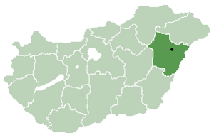
Location of Hajdú-Bihar county in Hungary
Körösszegapáti (Romanian: Apateu) is a village in Hajdú-Bihar County, in the Northern Great Plain region of eastern Hungary.
Geography
It covers an area of 45.85 km2 (18 sq mi) and has a population of 1012 people (2015).
References
- ↑ Gazetteer of Hungary, 1 January 2015. Hungarian Central Statistical Office. 3 September 2015
| City with county rights |
|   |
|---|---|---|
| Towns | ||
| Large villages | ||
| Villages |
| |
| Other topics |
| |
47°02′N 21°38′E / 47.033°N 21.633°E
This article is issued from Wikipedia. The text is licensed under Creative Commons - Attribution - Sharealike. Additional terms may apply for the media files.