| Khanui River | |
|---|---|
 | |
| Native name | Хануй гол (Mongolian) |
| Location | |
| Country | Mongolia |
| Aimags | Arkhangai, Bulgan |
| Physical characteristics | |
| Source | Khan-Öndör Uul |
| • location | Chuluut sum, Arkhangai aimag |
| • coordinates | 47°25′N 100°25′E / 47.417°N 100.417°E |
| Mouth | Selenga |
• location | Khishig-Öndör sum, Bulgan aimag |
• coordinates | 49°20′45″N 102°21′35″E / 49.34583°N 102.35972°E |
| Length | 421 km (262 mi) |
| Basin size | 14,620 km2 (5,640 sq mi) |
| Basin features | |
| Progression | Selenga→ Lake Baikal→ Angara→ Yenisey→ Kara Sea |
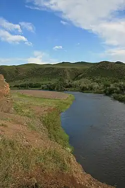
Khanui River (Mongolian: Хануй гол) is a river flowing down through the valleys of the Khangai Mountains in central Mongolia. It starts in the Chuluut sum of Arkhangai aimag at the north slopes of the Khan-Öndör mountain.[1] It passes next to the center of Erdenemandal sum, and ends in the Khutag-Öndör sum of Bulgan aimag where it discharges into the Selenge.[2] It is 421 kilometres (262 mi) long, and has a drainage basin of 14,600 square kilometres (5,600 sq mi).[3]
References
- ↑ "Russian army map "100k--l47-022"". Maps for the world. Retrieved 2015-01-04.
- ↑ "Russian army map "100k--m48-097"". Maps for the world. Retrieved 2015-01-04.
- ↑ Хануйн-Гол, Great Soviet Encyclopedia
This article is issued from Wikipedia. The text is licensed under Creative Commons - Attribution - Sharealike. Additional terms may apply for the media files.