| Kirkhamgate | |
|---|---|
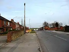 Brandy Carr Road, the main street in Kirkhamgate | |
 Kirkhamgate Location within West Yorkshire | |
| OS grid reference | SE300224 |
| Metropolitan borough | |
| Metropolitan county | |
| Region | |
| Country | England |
| Sovereign state | United Kingdom |
| Post town | WAKEFIELD |
| Postcode district | WF2 |
| Police | West Yorkshire |
| Fire | West Yorkshire |
| Ambulance | Yorkshire |
| UK Parliament | |
Kirkhamgate is a village in the Wakefield district, in West Yorkshire, England. It originated as a hamlet in the Alverthorpe township in the parish of Wakefield in the West Riding of Yorkshire.
Geography

Kirkhamgate is situated on rising ground at a junction on the Wakefield to Batley road to the east of the M1 motorway. It is primarily a residential village surrounded by farmland that is part of the Rhubarb Triangle.
Places adjacent to Kirkhamgate | ||||||||||||||||
|---|---|---|---|---|---|---|---|---|---|---|---|---|---|---|---|---|
| ||||||||||||||||
Events
Kirkhamgate holds an annual scarecrow festival in September.[1]
Governance
Alverthorpe civil parish was formed on 31 December 1894 from part of Alverthorpe with Thornes in Wakefield Rural District. On 1 April 1916 the parish was renamed Kirkhamgate. In 1931 the parish had a population of 1,320.[2] On 1 April 1937 the parish was abolished and merged with Stanley.[3][4]
References
- ↑ www.kirkhamgatescarecrows.co.uk Archived 19 April 2013 at the Wayback Machine
- ↑ "Population statistics Kirkhamgate CP through time". A Vision of Britain through Time. Retrieved 11 August 2023.
- ↑ "Wakefield Registration District". UKBMD. Retrieved 11 August 2023.
- ↑ "Relationships and changes Kirkhamgate CP through time". A Vision of Britain through Time. Retrieved 11 August 2023.
External links
![]() Media related to Kirkhamgate at Wikimedia Commons
Media related to Kirkhamgate at Wikimedia Commons