| Kronberg | |
|---|---|
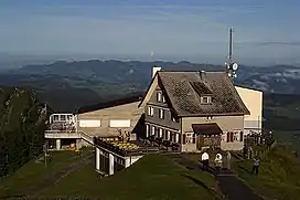 View from the summit | |
| Highest point | |
| Elevation | 1,663 m (5,456 ft) |
| Prominence | 351 m (1,152 ft)[1] |
| Parent peak | Säntis |
| Isolation | 3.2 km (2.0 mi) |
| Coordinates | 47°17′29″N 9°19′46″E / 47.29139°N 9.32944°E |
| Geography | |
 Kronberg Location in Switzerland | |
| Location | Appenzell Innerrhoden, Switzerland |
| Parent range | Appenzell Alps |
The Kronberg is a mountain of the Appenzell Alps, located west of Appenzell in the Swiss canton of Appenzell Innerrhoden. Its 1,663-metre-high (5,456 ft) summit can be accessed by cable car.
The Kronberg is an easily ascendable mountain and a popular excursion destination, and can also be hiked well on signposted snowshoe tours in winter. Valley station operates since June 28, 1999[2]
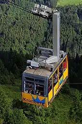
Kronberg cable car
See also
References
- ↑ Swisstopo maps
- ↑ Tourismus, Schweiz. "Motorikpark". Schweiz Tourismus (in German). Retrieved 2019-08-15.
External links
 Media related to Kronberg AI at Wikimedia Commons
- Kronberg Luftseilbahn
- Kronberg on Hikr
- Spherical panorama of Kronberg
This article is issued from Wikipedia. The text is licensed under Creative Commons - Attribution - Sharealike. Additional terms may apply for the media files.