Lafrançaise | |
|---|---|
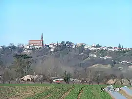 A general view of Lafrançaise | |
.svg.png.webp) Coat of arms | |
Location of Lafrançaise | |
 Lafrançaise  Lafrançaise | |
| Coordinates: 44°07′43″N 1°14′29″E / 44.1286°N 1.2414°E | |
| Country | France |
| Region | Occitania |
| Department | Tarn-et-Garonne |
| Arrondissement | Montauban |
| Canton | Pays de Serres Sud-Quercy |
| Intercommunality | Coteaux et Plaines du Pays Lafrançaisain |
| Government | |
| • Mayor (2020–2026) | Thierry Delbreil[1] |
| Area 1 | 50.82 km2 (19.62 sq mi) |
| Population | 2,852 |
| • Density | 56/km2 (150/sq mi) |
| Time zone | UTC+01:00 (CET) |
| • Summer (DST) | UTC+02:00 (CEST) |
| INSEE/Postal code | 82087 /82130 |
| Elevation | 65–213 m (213–699 ft) (avg. 190 m or 620 ft) |
| 1 French Land Register data, which excludes lakes, ponds, glaciers > 1 km2 (0.386 sq mi or 247 acres) and river estuaries. | |
Lafrançaise (French pronunciation: [lafʁɑ̃sɛz]; Languedocien: La Francesa) is a commune in the Tarn-et-Garonne department in the Occitanie region in southern France.
Population
| Year | Pop. | ±% p.a. |
|---|---|---|
| 1968 | 2,481 | — |
| 1975 | 2,545 | +0.36% |
| 1982 | 2,604 | +0.33% |
| 1990 | 2,651 | +0.22% |
| 1999 | 2,692 | +0.17% |
| 2007 | 2,805 | +0.52% |
| 2012 | 2,870 | +0.46% |
| 2017 | 2,850 | −0.14% |
| Source: INSEE[3] | ||
See also
References
- ↑ "Répertoire national des élus: les maires" (in French). data.gouv.fr, Plateforme ouverte des données publiques françaises. 13 September 2022.
- ↑ "Populations légales 2021". The National Institute of Statistics and Economic Studies. 28 December 2023.
- ↑ Population en historique depuis 1968, INSEE
Wikimedia Commons has media related to Lafrançaise.
This article is issued from Wikipedia. The text is licensed under Creative Commons - Attribution - Sharealike. Additional terms may apply for the media files.