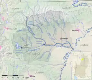
Map of the Duchesne drainage basin. Lake Fork joins the Duchesne southwest of Roosevelt.
The Lake Fork River is a river in Duchesne County, Utah in the United States.[1] It flows for 54 miles (87 km)[2] from Mount Lovenia in the Uinta Mountains, in a southeasterly direction, receiving the Yellowstone River above Mountain Home, to join the Duchesne River near Myton. The river is dammed near its headwaters to form Moon Lake, formerly a smaller natural lake.
Climate
Lakefork Basin is a SNOTEL weather station located near the source of the Lakefork River by Mount Lovenia.
| Climate data for Lakefork Basin, Utah, 1991–2020 normals, 1982-2020 extremes: 10966ft (3342m) | |||||||||||||
|---|---|---|---|---|---|---|---|---|---|---|---|---|---|
| Month | Jan | Feb | Mar | Apr | May | Jun | Jul | Aug | Sep | Oct | Nov | Dec | Year |
| Record high °F (°C) | 56 (13) |
62 (17) |
65 (18) |
66 (19) |
74 (23) |
77 (25) |
83 (28) |
76 (24) |
74 (23) |
70 (21) |
61 (16) |
50 (10) |
83 (28) |
| Mean maximum °F (°C) | 45.7 (7.6) |
46.3 (7.9) |
53.3 (11.8) |
58.0 (14.4) |
63.8 (17.7) |
70.5 (21.4) |
74.5 (23.6) |
71.8 (22.1) |
67.0 (19.4) |
60.8 (16.0) |
52.0 (11.1) |
43.5 (6.4) |
74.6 (23.7) |
| Mean daily maximum °F (°C) | 28.9 (−1.7) |
31.1 (−0.5) |
38.2 (3.4) |
42.9 (6.1) |
50.9 (10.5) |
58.8 (14.9) |
66.3 (19.1) |
64.4 (18.0) |
56.4 (13.6) |
45.9 (7.7) |
34.5 (1.4) |
27.8 (−2.3) |
45.5 (7.5) |
| Daily mean °F (°C) | 18.3 (−7.6) |
18.6 (−7.4) |
24.4 (−4.2) |
29.3 (−1.5) |
37.8 (3.2) |
46.4 (8.0) |
53.7 (12.1) |
51.9 (11.1) |
44.9 (7.2) |
35.1 (1.7) |
23.7 (−4.6) |
17.6 (−8.0) |
33.5 (0.8) |
| Mean daily minimum °F (°C) | 7.7 (−13.5) |
6.1 (−14.4) |
10.7 (−11.8) |
15.5 (−9.2) |
24.8 (−4.0) |
34.0 (1.1) |
41.1 (5.1) |
39.5 (4.2) |
33.2 (0.7) |
24.2 (−4.3) |
12.9 (−10.6) |
7.4 (−13.7) |
21.4 (−5.9) |
| Mean minimum °F (°C) | −10.8 (−23.8) |
−11.1 (−23.9) |
−6.5 (−21.4) |
0.2 (−17.7) |
9.0 (−12.8) |
22.5 (−5.3) |
34.5 (1.4) |
32.2 (0.1) |
21.0 (−6.1) |
6.8 (−14.0) |
−7.1 (−21.7) |
−11.4 (−24.1) |
−16.4 (−26.9) |
| Record low °F (°C) | −30 (−34) |
−29 (−34) |
−16 (−27) |
−16 (−27) |
−6 (−21) |
12 (−11) |
26 (−3) |
25 (−4) |
4 (−16) |
−6 (−21) |
−15 (−26) |
−25 (−32) |
−30 (−34) |
| Average precipitation inches (mm) | 3.77 (96) |
3.50 (89) |
3.26 (83) |
3.63 (92) |
3.20 (81) |
2.03 (52) |
2.26 (57) |
2.57 (65) |
2.81 (71) |
2.98 (76) |
3.22 (82) |
3.68 (93) |
36.91 (937) |
| Source 1: XMACIS2[3] | |||||||||||||
| Source 2: NOAA (Precipitation)[4] | |||||||||||||
See also
References
- ↑ U.S. Geological Survey Geographic Names Information System: Lake Fork River
- ↑ U.S. Geological Survey. National Hydrography Dataset high-resolution flowline data. The National Map Archived 2012-03-29 at the Wayback Machine, accessed 2016-05-13
- ↑ "xmACIS2". National Oceanic and Atmospheric Administration. Retrieved November 17, 2023.
- ↑ "Lakefork Basin, Utah 1991-2020 Monthly Normals". Retrieved November 17, 2023.
40°12′32″N 110°06′14″W / 40.2090°N 110.1038°W
This article is issued from Wikipedia. The text is licensed under Creative Commons - Attribution - Sharealike. Additional terms may apply for the media files.