Lulua District | |
|---|---|
District | |
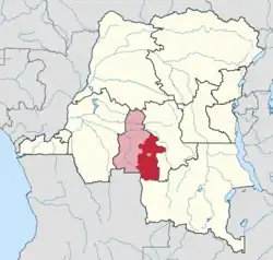 Lulua district in Kasai-Occidental province (2014) | |
| Coordinates: 05°54′S 21°27′E / 5.900°S 21.450°E | |
| Country | Democratic Republic of the Congo |
| Province | Kasai-Occidental |
| District | Lulua |
| Area | |
| • Total | 48,100 km2 (18,600 sq mi) |
Lulua District (French: District de la Lulua) was a district of the Belgian Congo and the Democratic Republic of the Congo. The city of Kananga (formerly known as Luluabourg) was at the center of the district, but had a separate administration. In 2015 Lulua District became the province of Kasaï-Central.
Territories
The district was divided into five territories:
History
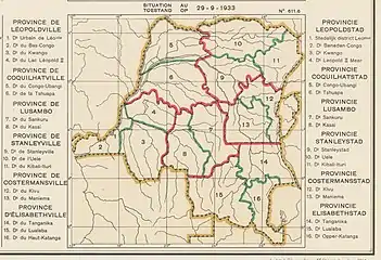
In 1933 the original four provinces of the Belgian Congo were reorganized into six provinces, named after their capitals, and the central government assumed more control.[1] Congo-Kasaï province was split, with the eastern part renamed Lusambo Province. The number of districts in the colony was reduced to 15.[2] Lusambo Province contained the districts of Sankuru to the east and Kasai to the west.[3] Lusambo Province was renamed Kasai Province in 1947 and some of the districts were divided up.
A 1955–1957 map shows that Sankuru District had been divided into a smaller Sankuru District to the north and a new Kabinda District to the south, while Kasai District had been divided into a smaller Kasai District to the west and a new Lulua district to the southeast.[4] Lulua District bordered Sankuru District to the north, Kabinda District to the east, Haut-Lomami District to the south, the Portuguese territories to the southwest and Kasai District to the west.[4] The area was 48,100 square kilometres (18,600 sq mi) out of a total of 323,100 square kilometres (124,700 sq mi) for Kasai province as a whole.[5]
Luluabourg province was created in 1962 from the former Kasai Province. It was incorporated into Kasai-Occidental in 1966 under the Mobutu regime. Presidents (from 1965, governors) of Luluabourg province were
- September 1962 - September 1963 François Luakabwanga (1st time)
- September 1963 - 25 September 1964 André Lubaya (d. 1968)
- 25 September 1964 - December 1965 François Luakabwanga (2nd time)
- January 1966 - 18 April 1966 Constantin Tshilumba
- 18 April 1966 - 25 April 1966 François Luakabwanga (3rd time)
Lulua was one of 25 new provinces specified in the country's Constitution (effective 18 February 2006).[6] Lulua District would be combined with the city of Kananga to form the new province, and Kananga would be the capital.[7] This was completed in 2015, forming the new province of Kasaï-Central.[8]
References
- ↑ Bruneau 2009, p. 8.
- ↑ Lemarchand 1964, p. 64.
- ↑ Atlas général du Congo.
- 1 2 Brass 2015, p. 243.
- ↑ Brass 2015, p. 255.
- ↑ Constitution de la République...
- ↑ "Provinces of the Democratic Republic of Congo". Statiods.com.
- ↑ RDC : le Kasaï-Occidental démembré.
Sources
- Atlas général du Congo / Algemene atlas van Congo (in French and Dutch), Belgium: Institut Royal Colonial Belge, 1948–1963, OCLC 681334449
- Brass, William (8 December 2015), Demography of Tropical Africa, Princeton University Press, ISBN 978-1-4008-7714-0, retrieved 20 August 2020
- Bruneau, Jean-Claude (30 June 2009), "Les nouvelles provinces de la République Démocratique du Congo : construction territoriale et ethnicités", L'Espace Politique, 7 (2009–1), doi:10.4000/espacepolitique.1296, retrieved 2020-08-08
- "Constitution de la République démocratique du Congo: Article 2". Wikisource.
- Lemarchand, René (1964), Political Awakening in the Belgian Congo, University of California Press, GGKEY:TQ2J84FWCXN, retrieved 19 August 2020
- Omasombo Tshonda, Jean (2015), Mongala : Jonction des territoires et bastion d'une identité supra-ethnique (PDF), Musée royal de l’Afrique centrale, ISBN 978-9-4922-4416-1, retrieved 2020-08-18
- "RDC : le Kasaï-Occidental démembré", Radio Okapi (in French), 18 July 2015, archived from the original on 13 August 2015, retrieved 2 June 2020