| Matagalls | |
|---|---|
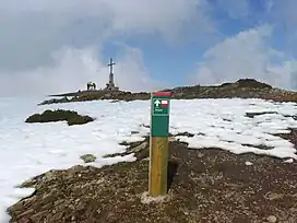 Matagalls summit in the winter | |
| Highest point | |
| Elevation | 1,697 m (5,568 ft) |
| Prominence | 597 m (1,959 ft) |
| Isolation | 5.54 km (3.44 mi) to Les Agudes |
| Coordinates | 41°48′31.66″N 2°22′57.86″E / 41.8087944°N 2.3827389°E |
| Geography | |
| Location | Vallès Oriental, Osona, Catalonia |
| Parent range | Montseny |
| Climbing | |
| First ascent | Unknown |
| Easiest route | From Sant Marçal or Coll Formic |
Matagalls is one of the highest mountains of the Montseny Massif, Catalonia, Spain. It has an elevation of 1,697.9 metres above sea level.[1]
See also
References
- ↑ "Mapa Topogràfic de Catalunya". Institut Cartogràfic de Catalunya. Retrieved May 22, 2010..
External links
This article is issued from Wikipedia. The text is licensed under Creative Commons - Attribution - Sharealike. Additional terms may apply for the media files.