Mattawan | |
|---|---|
Municipality (single-tier) | |
| Municipality of Mattawan | |
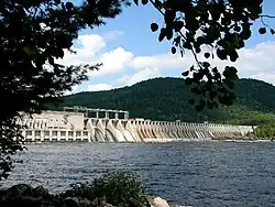 The Otto Holden Generating Station and dam across the Ottawa River. | |
 Mattawan | |
| Coordinates: 46°20′N 78°50′W / 46.333°N 78.833°W | |
| Country | Canada |
| Province | Ontario |
| District | Nipissing |
| Government | |
| • Mayor | Peter Murphy |
| Area | |
| • Land | 201.00 km2 (77.61 sq mi) |
| Population (2016)[2] | |
| • Total | 161 |
| • Density | 0.8/km2 (2/sq mi) |
| Time zone | UTC-5 (Eastern (EST)) |
| Postal code | P0H 1V0 |
| Area code(s) | 705, 249 |
| Website | Official website |
Mattawan is a municipality in the Canadian province of Ontario. Located in the Nipissing District, the municipality had a population of 161 in the Canada 2016 Census.
The municipality has no named communities within its boundaries; all addresses within the municipality are rural routes assigned to the neighbouring town of Mattawa.
Its main access road is Highway 533, with Highway 656 as a short branch leading to the Otto Holden Generating Station on the Ottawa River.
In 2007, Mattawan, along with the town of Mattawa and the townships of Papineau-Cameron, Bonfield and Calvin cooperated to create a newly branded Mattawa Voyageur Country tourist region in order to promote the area.[3]
Demographics
In the 2021 Census of Population conducted by Statistics Canada, Mattawan had a population of 153 living in 71 of its 102 total private dwellings, a change of -5% from its 2016 population of 161. With a land area of 200.12 km2 (77.27 sq mi), it had a population density of 0.8/km2 (2.0/sq mi) in 2021.[4]
| 2021 | 2016 | 2011 | |
|---|---|---|---|
| Population | 153 (-5.0% from 2016) | 161 (-0.6% from 2011) | 162 (+10.2% from 2006) |
| Land area | 200.12 km2 (77.27 sq mi) | 201.00 km2 (77.61 sq mi) | 200.96 km2 (77.59 sq mi) |
| Population density | 0.8/km2 (2.1/sq mi) | 0.8/km2 (2.1/sq mi) | 0.8/km2 (2.1/sq mi) |
| Median age | 53.2 (M: 53.2, F: 54.4) | 53.9 (M: 55.4, F: 53.5) | |
| Private dwellings | 70 (total) | 104 (total) | 99 (total) |
| Median household income | $77,312 |
| Year | Pop. | ±% |
|---|---|---|
| 1991 | 127 | — |
| 1996 | 115 | −9.4% |
| 2001 | 114 | −0.9% |
| 2006 | 147 | +28.9% |
| 2011 | 162 | +10.2% |
| 2016 | 161 | −0.6% |
| [10][1][2] | ||
See also
References
- 1 2 "Mattawan census profile". 2011 Census of Population. Statistics Canada. Retrieved 2012-02-09.
- 1 2 "Census Profile, 2016 Census: Mattawan, Township". Statistics Canada. 8 February 2017. Retrieved June 24, 2019.
- ↑ Adams, K. "Mattawa sports a new look", Baytoday.ca, July 17, 2007. Accessed March 28, 2008.
- ↑ "Population and dwelling counts: Canada, provinces and territories, census divisions and census subdivisions (municipalities), Ontario". Statistics Canada. February 9, 2022. Retrieved April 2, 2022.
- ↑ "2021 Community Profiles". 2021 Canadian Census. Statistics Canada. February 4, 2022. Retrieved 2022-04-27.
- ↑ "2016 Community Profiles". 2016 Canadian Census. Statistics Canada. August 12, 2021. Retrieved 2019-06-24.
- ↑ "2011 Community Profiles". 2011 Canadian Census. Statistics Canada. March 21, 2019. Retrieved 2012-02-09.
- ↑ "2006 Community Profiles". 2006 Canadian Census. Statistics Canada. August 20, 2019.
- ↑ "2001 Community Profiles". 2001 Canadian Census. Statistics Canada. July 18, 2021.
- ↑ Statistics Canada: 1996, 2001, 2006 census
External links
Places adjacent to Mattawan, Ontario | |
|---|---|
| Cities | 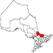 | |
|---|---|---|
| Towns | ||
| Townships | ||
| First Nations | ||
| Indian reserves | ||
| Unorganized areas | ||
| Local services boards | ||
| ||