Mele
Mê | |
|---|---|
| Comune di Mele | |
 | |
 Coat of arms | |
Location of Mele | |
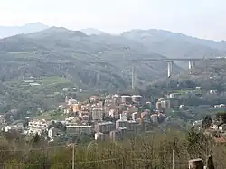
 Mele Location of Mele in Italy  Mele Mele (Liguria) | |
| Coordinates: 44°27′N 8°45′E / 44.450°N 8.750°E | |
| Country | Italy |
| Region | Liguria |
| Metropolitan city | Genoa (GE) |
| Frazioni | Acquasanta, Biscaccia, Fado, Ferriera/Fondocrosa |
| Government | |
| • Mayor | Mirco Ferrando |
| Area | |
| • Total | 16.9 km2 (6.5 sq mi) |
| Elevation | 125 m (410 ft) |
| Population | |
| • Total | 2,687 |
| • Density | 160/km2 (410/sq mi) |
| Demonym | Melesi |
| Time zone | UTC+1 (CET) |
| • Summer (DST) | UTC+2 (CEST) |
| Postal code | 16010 |
| Dialing code | 010 |
| Patron saint | Antonio |
| Saint day | 17 Gennaio |
| Website | Official website |
Mele (Ligurian: Mê) is a Comune (Municipality) in the Metropolitan City of Genoa in the Italian region Liguria, located about 21 kilometres (13 mi) west of Genoa.
References
- ↑ "Superficie di Comuni Province e Regioni italiane al 9 ottobre 2011". Italian National Institute of Statistics. Retrieved 16 March 2019.
- ↑ All demographics and other statistics: Italian statistical instituteIstat.
- ↑ "Popolazione Residente al 1° Gennaio 2018". Italian National Institute of Statistics. Retrieved 16 March 2019.
External links
This article is issued from Wikipedia. The text is licensed under Creative Commons - Attribution - Sharealike. Additional terms may apply for the media files.