Norðradalur | |
|---|---|
Village | |
 Norðradalur, Faroe Islands | |
 Norðradalur Location in the Faroe Islands | |
| Coordinates: 62°2′25″N 6°55′22″W / 62.04028°N 6.92278°W | |
| State | |
| Constituent country | |
| Island | Streymoy |
| Municipality | Tórshavn Municipality |
| Population (1 January 2006) | |
| • Total | 15 |
| Time zone | GMT |
| • Summer (DST) | UTC+1 (EST) |
| Postal code | FO 178 |
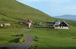
Norðradalur (Danish: Nordredal) is a village on the western coast of the Faroese island of Streymoy in Tórshavn Municipality. The 2015 population was 15. Its postal code is FO 178. The village lies in a large valley surrounded be steep cliffs and the ocean, with views over Koltur.
Norðradalur has a columnar basalt wall, which is used as the main climbing area for the young, but growing Faroese climbing community.[1]
See also
References
External links
Wikimedia Commons has media related to Norðradalur.
This article is issued from Wikipedia. The text is licensed under Creative Commons - Attribution - Sharealike. Additional terms may apply for the media files.