| Scottish Gaelic name | Orasaigh |
|---|---|
| Old Norse name | Örfirirsey |
| Meaning of name | tidal or ebb island |
 Oronsay | |
| Location | |
 Oronsay Oronsay shown within the Outer Hebrides | |
| OS grid reference | NF845755 |
| Coordinates | 57°40′N 7°17′W / 57.66°N 7.29°W |
| Physical geography | |
| Island group | Uist and Barra |
| Area | 85 ha (0.33 sq mi) |
| Area rank | 157= [1] |
| Highest elevation | 25 m (82 ft) |
| Administration | |
| Sovereign state | United Kingdom |
| Country | Scotland |
| Council area | Na h-Eileanan Siar |
| Demographics | |
| Population | 0 |
| References | [2][3][4][5] |
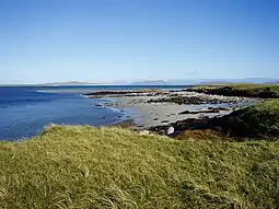
Oronsay (Gaelic Orasaigh) is a tidal island off North Uist in the Outer Hebrides. Lying to the north of Vallaquie Strand, the island has been uninhabited since the Highland Clearances.[3]
Footnotes
- ↑ Area and population ranks: there are c. 300 islands over 20 ha in extent and 93 permanently inhabited islands were listed in the 2011 census.
- ↑ 2001 UK Census per List of islands of Scotland
- 1 2 Haswell-Smith, Hamish (2004). The Scottish Islands. Edinburgh: Canongate. ISBN 978-1-84195-454-7.
- ↑ Ordnance Survey
- ↑ Iain Mac an Tailleir. "Placenames" (PDF). Pàrlamaid na h-Alba. Retrieved 28 July 2007.

57°39′49″N 7°17′30″W / 57.66361°N 7.29167°W
This article is issued from Wikipedia. The text is licensed under Creative Commons - Attribution - Sharealike. Additional terms may apply for the media files.