 | ||||
|---|---|---|---|---|
 | ||||
| Route information | ||||
| Part of | ||||
| Length | 32 km (20 mi) | |||
| Existed | 1992–present | |||
| Major junctions | ||||
| West end | ||||
| East end | ||||
| Location | ||||
| Country | Turkey | |||
| Regions | Central Anatolia | |||
| Provinces | Konya, Niğde | |||
| Highway system | ||||
| ||||
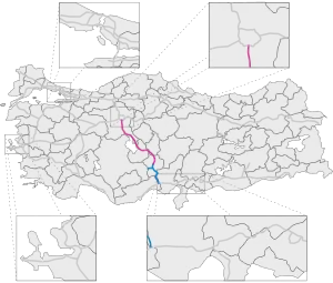
Otoyol 21A, abbreviated as O-21A, is a 32 km (20 mi) long auxiliary otoyol connecting the D.330 and D.750 to the O-21. The motorway was opened in 1992 as a connecting route to Konya and passes through mostly uninhabited rural land. The O-21A is a part of the E90.
The motorway was deemed too short to receive its own O-XX designation, despite being longer than the O-50, but too long to be designated as an exit; therefore, the route was signed as the O-21A, and is the only otoyol route in Turkey to have an alpha-numeric route designation.
Exit list
| Province | District | km | mi | Exit | Destination | Notes |
|---|---|---|---|---|---|---|
| Konya | Ereğli | 0.0 | 0.0 | - | Continues as the D.330 | |
| 0.6 | 0.4 | K153 | ||||
| Niğde | Ulukışla | 17.6 | 10.9 | K152 | ||
| 28.8 | 17.9 | K151 | Eminlik | |||
| 30.1 | 18.7 | Eminlik Toll Plaza | ||||
| 32.3 | 20.1 | K15 | ||||
Light blue indicates toll section of motorway.
See also
External links
- Mersin Diyarbakır road map Archived 2011-07-25 at the Wayback Machine
| Current | ||
|---|---|---|
| Former | ||
| Planned |
| |
| ||
This article is issued from Wikipedia. The text is licensed under Creative Commons - Attribution - Sharealike. Additional terms may apply for the media files.