Route 350 | ||||
|---|---|---|---|---|
 | ||||
| Route information | ||||
| Maintained by Ministère des transports du Québec | ||||
| Length | 28.3 km[1] (17.6 mi) | |||
| Major junctions | ||||
| West end | ||||
| East end | ||||
| Location | ||||
| Country | Canada | |||
| Province | Quebec | |||
| Major cities | Saint-Edouard-de-Maskinonge, Saint-Boniface-de-Shawinigan, Saint-Paulin | |||
| Highway system | ||||
| ||||

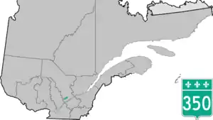
Route 350 is a provincial highway located in the Mauricie region of Quebec. It runs from the junction of Route 348 in Saint-Édouard-de-Maskinongé to the junction of Route 153 west of Saint-Boniface-de-Shawinigan. It overlaps Route 349 in Saint-Paulin and Route 351 in Charette.
Towns along Route 350
.jpg.webp)
Quebec Route 350 in Saint-Boniface
Major intersections
| RCM or ET | Municipality | Km | Junction | Notes |
|---|---|---|---|---|
Western terminus of Route 350 | ||||
| Maskinongé | Saint-Édouard-de-Maskinongé | 0.0 | ||
| Saint-Paulin | 10.7 | Western terminus of Route 349 / Route 350 overlap | ||
| 14.0 | Eastern terminus of Route 349 / Route 350 overlap Rue Lafèche to Hunterstown | |||
| Charette | 22.2 | Western terminus of Route 350 / Route 351 overlap | ||
| 23.9 | Eastern terminus of Route 350 / Route 351 overlap | |||
| Saint-Boniface | 28.9 | |||
Eastern terminus of Route 350 | ||||
See also
References
- ↑ Ministère des transports, "Distances routières", page 102, Les Publications du Québec, 2005
External links
- Transports Quebec Official Road Map (in French)
- Route 350 on Google Maps
This article is issued from Wikipedia. The text is licensed under Creative Commons - Attribution - Sharealike. Additional terms may apply for the media files.