Rahadi Usman Airport Bandar Udara Rahadi Usman | |||||||||||
|---|---|---|---|---|---|---|---|---|---|---|---|
 | |||||||||||
| Summary | |||||||||||
| Airport type | Public | ||||||||||
| Owner | Government of Indonesia | ||||||||||
| Operator | Ministry of Transportation | ||||||||||
| Location | Ketapang, West Kalimantan, Indonesia | ||||||||||
| Time zone | WIB (UTC+07:00) | ||||||||||
| Elevation AMSL | 46 ft / 14 m | ||||||||||
| Coordinates | 01°48′59″S 109°57′48″E / 1.81639°S 109.96333°E | ||||||||||
| Map | |||||||||||
 KTG Location of airport in Indonesia | |||||||||||
| Runways | |||||||||||
| |||||||||||
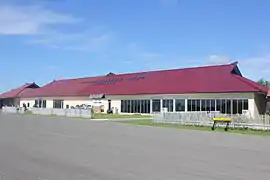
Rahadi Usman Airport or Rahadi Oesman Airport (IATA: KTG, ICAO: WIOK), also known as Ketapang Airport, is an airport in Ketapang, West Kalimantan, Indonesia. Rahadi Usman Airport is named after local freedom fighter, Rahadi Usman (id).
Airlines and destinations
| Airlines | Destinations |
|---|---|
| Wings Air | Pontianak,[3] Semarang |
References
- ↑ "Airport information for WIOK". World Aero Data. Archived from the original on 2019-03-05.
{{cite web}}: CS1 maint: unfit URL (link) Data current as of October 2006. Source: DAFIF. - ↑ Airport information for WIOK at Great Circle Mapper. Source: DAFIF (effective October 2006).
- ↑ "Default". agent.lionair.co.id. Retrieved 2020-06-04.
External links
- Rahadi Osman Airport - Indonesia Airport Global Website
- Accident history for KTG at Aviation Safety Network
This article is issued from Wikipedia. The text is licensed under Creative Commons - Attribution - Sharealike. Additional terms may apply for the media files.