Rio Pardo | |
|---|---|
| Municipality of Rio Pardo | |
 Flag  Coat of arms | |
 Location in Rio Grande do Sul state | |
 Rio Pardo Location in Brazil | |
| Coordinates: 29°59′23″S 52°22′41″W / 29.98972°S 52.37806°W | |
| Country | |
| Region | South |
| State | |
| Area | |
| • Total | 2,051 km2 (792 sq mi) |
| Elevation | 41 m (135 ft) |
| Population (2020 [1]) | |
| • Total | 38,265 |
| • Density | 19/km2 (48/sq mi) |
| Time zone | UTC−3 (BRT) |
| HDI (2010) | 0.754 – high[2] |
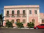
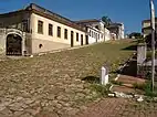

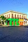
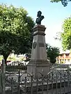

Rio Pardo is a municipality in the state of Rio Grande do Sul in Brazil. The population is 38,265 (2020 est.) in an area of 2051 km².[3] The elevation is 41 m.
References
- ↑ IBGE 2020
- ↑ "Archived copy" (PDF). United Nations Development Programme (UNDP). Archived from the original (PDF) on July 8, 2014. Retrieved August 1, 2013.
{{cite web}}: CS1 maint: archived copy as title (link) - ↑ Instituto Brasileiro de Geografia e Estatística

This article is issued from Wikipedia. The text is licensed under Creative Commons - Attribution - Sharealike. Additional terms may apply for the media files.