Santa Bárbara | |
|---|---|
City district | |
_Vista_a%C3%A9rea_de_Toledo_(cropped).jpg.webp) | |
 | |
| Country | Spain |
| Region | Castilla–La Mancha |
| Municipality | Toledo |
| Population (2018) | |
| • Total | 7,888 |
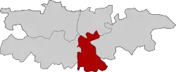
Santa Bárbara is a district (number 2) and neighborhood of Toledo, Spain.
Through the Cuesta de San Servando, the urbanised area is connected to the historic centre[1] (at the opposite bank of the Tagus) as well as to the Castle of San Servando, the Toledo Infantry Academy and the Provincial Hospital of Toledo,[1] which are all located within the district limits. It has its own football turf, located in the east of the urbanised area.[2] As of 1 January 2018, the district has a population of 7,888 inhabitants (the district consists solely of the namesake neighborhood).[3]
References
- 1 2 "Santa Bárbara y la Academia de Infantería, conectadas a finales de marzo". ABC. 20 February 2019.
- ↑ "Toledo revitaliza su campo de fútbol de Santa Bárbara". Mondo. 16 November 2016.
- ↑ "Evolución de la población por barrios y distritos". Ayuntamiento de Toledo. Retrieved 23 March 2020.
This article is issued from Wikipedia. The text is licensed under Creative Commons - Attribution - Sharealike. Additional terms may apply for the media files.