Sirok | |
|---|---|
Village | |
 Sirok Castle ruins | |
 Flag  Coat of arms | |
 Sirok Location of Sirok | |
| Coordinates: 47°55′52″N 20°11′45″E / 47.93111°N 20.19583°E | |
| Country | Hungary |
| Region | Northern Hungary |
| County | Heves |
| District | Pétervására |
| Area | |
| • Total | 63.39 km2 (24.48 sq mi) |
| Population (1 January 2023)[1] | |
| • Total | 1,629 |
| • Density | 26/km2 (67/sq mi) |
| Time zone | UTC+1 (CET) |
| • Summer (DST) | UTC+2 (CEST) |
| Postal code | 3332 |
| Area code | (+36) 36 |
| Website | www |
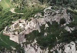
Aerial Photo: Sirok - Castle
Sirok is a historic village (population 2,100) in Heves county in Hungary, situated near Eger in Mátra mountains in the valley of Tarna creek. Today it is most known for its 13th-century castle ruins.
Etymology
The name comes from the Slavic širokъ—wide like Široka Planina, Široký Důl and many other similar Slavic names.[2][3]
References
- ↑ Error: Unable to display the reference properly. See the documentation for details.
- ↑ Kiss, Lajos (1978). Földrajzi nevek etimológiai szótára (in Hungarian). Budapest: Akadémiai. p. 574.
- ↑ Stanislav, Ján (2004). Slovenský juh v stredoveku II (in Slovak). Slovenské literárne centrum. p. 434. ISBN 80-88878-89-6.
| Town (1) |
| |
|---|---|---|
| Large villages (2) | ||
| Villages (17) | ||


This article is issued from Wikipedia. The text is licensed under Creative Commons - Attribution - Sharealike. Additional terms may apply for the media files.