| Strogen | |
|---|---|
 | |
| Location | |
| Country | Germany |
| State | Bavaria |
| Physical characteristics | |
| Source | |
| • location | northwest of Buch am Buchrain |
| • elevation | 520 m (1,710 ft) |
| Mouth | |
• location | into the Sempt east of Moosburg |
• coordinates | 48°28′00″N 11°58′42″E / 48.4667°N 11.9784°E |
• elevation | 415 m (1,362 ft) |
| Length | 39.7 km (24.7 mi) [1] |
| Basin size | 146.48 km2 (56.56 sq mi) [1] |
| Basin features | |
| Progression | Sempt→ Isar→ Danube→ Black Sea |
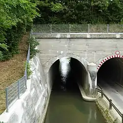
Strogen is a river of Bavaria, Germany. It is a right tributary of the Sempt, is approximately 40 km in length, and drains a basin of approximately 146 km2 (56 sq mi). Its source is northwest of Buch am Buchrain in the district Erding. On its way north, the river splits into a main channel and the parallel "Strogenkanal", both of which join the Sempt, a tributary of the Isar, near Moosburg.[2]
See also
References
- 1 2 Complete table of the Bavarian Waterbody Register by the Bavarian State Office for the Environment (xls, 10.3 MB)
- ↑ Verzeichnis der Bach- und Flussgebiete in Bayern – Flussgebiet Isar (PDF). Bayerisches Landesamt für Umwelt. 2012. p. 78.
This article is issued from Wikipedia. The text is licensed under Creative Commons - Attribution - Sharealike. Additional terms may apply for the media files.