| Townshend Dam | |
|---|---|
 Townshend Lake, Vermont | |
| Country | United States |
| Coordinates | 43°3′9.58″N 72°42′9.68″W / 43.0526611°N 72.7026889°W |
| Dam and spillways | |
| Height (foundation) | 126 feet (38 m) |
| Length | 1,700 feet (520 m) |
| Reservoir | |
| Total capacity | 800 acre-feet (987,000 m3) |
| Surface area | 95 acres (38 ha) |
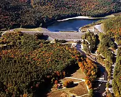
Townshend Dam is a dam in Townshend, Windham County, Vermont.
The earthen dam was constructed in 1961 by the United States Army Corps of Engineers with a height of 126 feet and a length of 1700 feet at its crest.[1] It impounds Vermont's West River for flood control and seasonal storm water management. The dam is owned and operated by the Corps of Engineers.[2] Its National ID number is VT00004.
The riverine reservoir it creates, Townshend Lake, has a normal water surface of 95 acres, a maximum storage capacity of 54,300 acre-feet, and a normal storage capacity of 800 acre-feet.[1] Recreation includes fishing (for smallmouth bass, brown and rainbow trout), boating and hiking,[3] along with facilities at the nearby Townshend State Park.[4]
References
- 1 2 "Find Lakes".
- ↑ "Archived copy". Archived from the original on 2014-09-04. Retrieved 2012-09-06.
{{cite web}}: CS1 maint: archived copy as title (link) - ↑ "Corps Lakes Gateway: Vermont - Townshend Lake".
- ↑ "Vermont State Parks - Townshend State Park". Archived from the original on 2012-08-14.
This article is issued from Wikipedia. The text is licensed under Creative Commons - Attribution - Sharealike. Additional terms may apply for the media files.