Truckton, Colorado | |
|---|---|
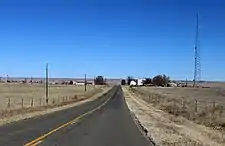 Looking north from just south of Truckton. | |
 Truckton Location within the state of Colorado | |
| Coordinates: 38°44′17″N 104°10′56″W / 38.73806°N 104.18222°W | |
| Country | United States |
| State | Colorado |
| County | El Paso |
| Time zone | UTC-7 (Mountain (MST)) |
| • Summer (DST) | UTC-6 (MDT) |
| ZIP codes | 80864[1] |
| Area code | 719[2] |
| GNIS feature ID | 193631 |
Truckton is an unincorporated prairie hamlet in El Paso County, Colorado, south of State Highway 94, at and about the intersection of Truckton Road and Boone Road.[3] There is a church at Truckton, also a communications tower, but no other businesses or services; and several scattered homes.
References
- ↑ USPS.com
- ↑ allareacodes.com
- ↑ Official Colorado map
Municipalities and communities of El Paso County, Colorado, United States | ||
|---|---|---|
| Cities |  Map of Colorado highlighting El Paso County | |
| Towns | ||
| CDPs | ||
| Unincorporated communities | ||
| Ghost towns | ||
| Footnotes | ‡This populated place also has portions in an adjacent county or counties | |
This article is issued from Wikipedia. The text is licensed under Creative Commons - Attribution - Sharealike. Additional terms may apply for the media files.