University | |
|---|---|
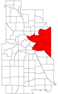 Location of University within the U.S. city of Minneapolis | |
| Coordinates: 44°59′0″N 93°14′0″W / 44.98333°N 93.23333°W | |
| Country | United States |
| State | Minnesota |
| County | Hennepin |
| City | Minneapolis |
| Neighborhoods | |
| Area | |
| • Total | 5.714 sq mi (14.80 km2) |
| Population (2020)[2] | |
| • Total | 51,922 |
| • Density | 9,100/sq mi (3,500/km2) |
| Time zone | UTC-6 (CST) |
| • Summer (DST) | UTC-5 (CDT) |
| ZIP code | 55401, 55413, 55414, 55454, 55455 |
| Area code | 612 |
| Census | Pop. | Note | %± |
|---|---|---|---|
| 1980 | 29,818 | — | |
| 1990 | 30,464 | 2.2% | |
| 2000 | 33,440 | 9.8% | |
| 2010 | 38,785 | 16.0% | |
| 2020 | 51,922 | 33.9% |
University is a community in Minneapolis. It is composed of six smaller neighborhoods. It also contains the University of Minnesota campus and the Mid-City Industrial Area, which is not assigned to an official neighborhood.
Official neighborhoods in the University community
- Cedar-Riverside, also known as the West Bank
- Como
- Marcy-Holmes part of this neighborhood contains an area more commonly known as Dinkytown.
- Nicollet Island/East Bank
- Prospect Park
- University
References
- ↑ "University neighborhood in Minneapolis, Minnesota (MN), 55413, 55414, 55454, 55455 detailed profile". City-Data. 2011. Retrieved 2013-11-12.
- ↑ "University community data". Minnesota Compass. Retrieved 2023-04-02.
This article is issued from Wikipedia. The text is licensed under Creative Commons - Attribution - Sharealike. Additional terms may apply for the media files.