Vilvestre | |
|---|---|
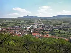 View of Vilvestre | |
 Flag  Coat of arms | |
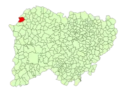 Location of Vilvestre in Salamanca | |
 Vilvestre Location in Spain | |
| Coordinates: 41°06′11″N 6°43′07″W / 41.10306°N 6.71861°W | |
| Country | Spain |
| Autonomous community | Castile and León |
| Province | Salamanca |
| Comarca | Vitigudino |
| Subcomarca | La Ribera de Salamanca |
| Government | |
| • Mayor | Manuel Domínguez Hernández (People's Party) |
| Area | |
| • Total | 46.52 km2 (17.96 sq mi) |
| Elevation | 592 m (1,942 ft) |
| Population (2018)[2] | |
| • Total | 422 |
| • Density | 9.1/km2 (23/sq mi) |
| Time zone | UTC+1 (CET) |
| • Summer (DST) | UTC+2 (CEST) |
| Area code | 34 (Spain) + 923 (Salamanca) |
| Website | www.vilvestre.es |
Vilvestre is a village and municipality in the province of Salamanca, western Spain, part of the autonomous community of Castile-Leon. It is located 96 kilometres from the provincial capital city of Salamanca and has a population of 468 people.
Geography
The municipality covers an area of 47 km2. It lies 592 metres above sea level and the postal code is 37258.[1]
Climate
Situated on the Río Duero, the climate is typical of the Mediterranean with orange and olive groves.
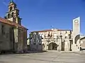 City hall of Vilvestre.
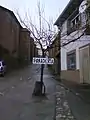 Bakery in Vilvestre.
.jpg.webp) 'Todos los Santos' day, Vilvestre.
'Todos los Santos' day, Vilvestre.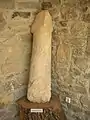 Prehistoric statue of a penis in the Vilvestre Museum.
References
- 1 2 3 "Municipio:Vilvestre". www.lasalina.es (in Spanish). Retrieved 2017-10-28.
- ↑ Municipal Register of Spain 2018. National Statistics Institute.
This article is issued from Wikipedia. The text is licensed under Creative Commons - Attribution - Sharealike. Additional terms may apply for the media files.